Tlmače geodata
Tlmače (Nitriansky kraj) is a populated place; located in Slovakia in Europe/Bratislava (GMT+2) time zone. With population of 4,305 people, there are 119 cities with bigger population in this country. Compared to other cities in Slovakia, 81.2% of cities are located further ↑North; 66.5% of cities are located further →East and 73.5% of cities have higher elevation than Tlmače. Note1


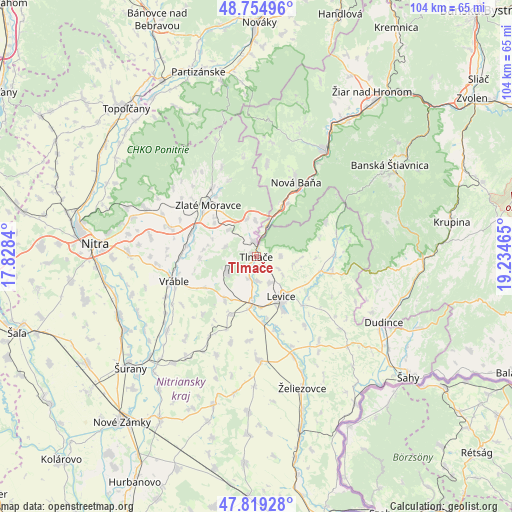
Tlmače GPS coordinates[2]
48° 17' 21.336" North, 18° 31' 53.472" East
| Map corner | latitude | longitude |
|---|---|---|
| Upper-left | 48.75496°, | 17.8284° |
| Center: | 48.28926°, | 18.53152° |
| Lower-right: | 47.81928°, | 19.23465° |
| Map W x H: | 104×104 km | = 64.6×64.6mi |
| max Lat: | 49.43503° ⇑81.2% North |
| Tlmače: | 48.28926° |
| min Lat: | ⇓18.8% South 47.76356° |
| min Long | Tlmače | max Long |
| 16.9786° | 18.53152° | 22.18136° |
| W 33.5%⇐ | ⇒66.5% E |
Elevation
Elevation of Tlmače is 174 m = 571 ft, and this is 162.1 m = 532 ft below average elevation for this country.
| Max E: |
1006 m = 3301 ft | 73.5% |
| Avg. | 336.1 m = 1103 ft | |
| Tlmače | 174 m = 571 ft | |
Min E: |
102 m = 335 ft | 26.5% |
See also: Slovakia elevation on elevation.city.
Geographical zone
Tlmače is located in North temperate zone (between Tropic of Cancer and the Arctic Circle). Distance of this North polar circle is 2031.9 km =1262.6 mi to North.| Distance of | km | miles | from Tlmače |
|---|---|---|---|
| North Pole | 4637.8 | 2881.8 | to North |
| Arctic Circle | 2031.9 | 1262.6 | to North |
| Tropic Cancer | 2763.3 | 1717 | to South |
| Equator | 5369.3 | 3336.3 | to South |


Nearby cities:
15 places around Tlmače: (largest is in red/bold)
• Banská Štiavnica
33.1 km =20.6 mi,  57°
57°
• Dudince
29.5 km =18.3 mi,  116°
116°
• Komárno
24.9 km =15.5 mi,  219°
219°
• Levice
9.9 km =6.2 mi,  145°
145°
• Nitra
33.1 km =20.6 mi,  273°
273°
• Nová Baňa
16.9 km =10.5 mi,  28°
28°
• Partizánske
39.3 km =24.4 mi,  343°
343°
• Svätý Anton
33.5 km =20.8 mi, 64°
• Voznica
22.7 km =14.1 mi, 33°
• Vráble
17.3 km =10.7 mi,  252°
252°
• Zlaté Moravce
14.4 km =8.9 mi,  317°
317°
• Šahy
39.1 km =24.3 mi,  127°
127°
• Šurany
34.2 km =21.3 mi,  228°
228°
• Žarnovica
25.3 km =15.7 mi, 32°
• Želiezovce
28 km =17.4 mi,  161°
161°
Sources, notices
• [Note1] Compared only with cities in Slovakia existing in our database
• [Src1] Map data: © OpenStreetMap contributors (CC-BY-SA)
• [Src2] Other city data from geonames.org with taken over terms of usage.
• [Src3] Geographical zone / Annual Mean Temperature by Robert A. Rohde @ Wikipedia
