Galanta geodata
Galanta (Trnavský kraj) is a populated place; located in Slovakia in Europe/Bratislava (GMT+2) time zone. With population of 16,365 people, there are 47 cities with bigger population in this country. Compared to other cities in Slovakia, 88.2% of cities are located further ↑North; 84.1% of cities are located further →East and 91.8% of cities have higher elevation than Galanta. Note1


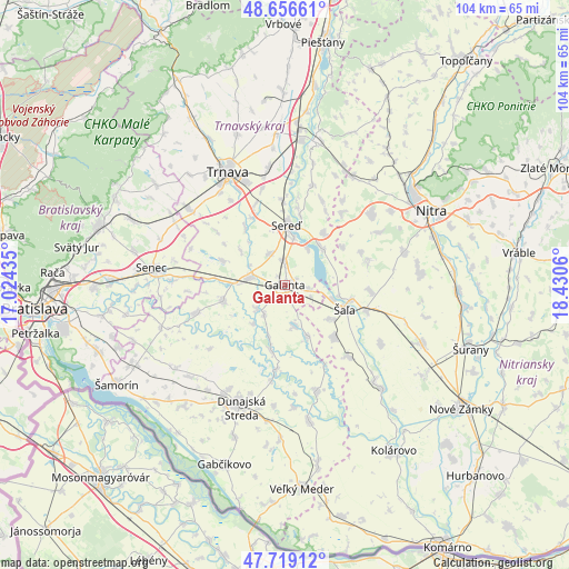
Galanta GPS coordinates[2]
48° 11' 24.036" North, 17° 43' 38.892" East
| Map corner | latitude | longitude |
|---|---|---|
| Upper-left | 48.65661°, | 17.02435° |
| Center: | 48.19001°, | 17.72747° |
| Lower-right: | 47.71912°, | 18.4306° |
| Map W x H: | 104.2×104.2 km | = 64.7×64.7mi |
| max Lat: | 49.43503° ⇑88.2% North |
| Galanta: | 48.19001° |
| min Lat: | ⇓11.8% South 47.76356° |
| min Long | Galanta | max Long |
| 16.9786° | 17.72747° | 22.18136° |
| W 15.9%⇐ | ⇒84.1% E |
Elevation
Elevation of Galanta is 119 m = 390 ft, and this is 217.1 m = 712 ft below average elevation for this country.
| Max E: |
1006 m = 3301 ft | 91.8% |
| Avg. | 336.1 m = 1103 ft | |
| Galanta | 119 m = 390 ft | |
Min E: |
102 m = 335 ft | 8.2% |
See also: Slovakia elevation on elevation.city.
Geographical zone
Galanta is located in North temperate zone (between Tropic of Cancer and the Arctic Circle). Distance of this North polar circle is 2042.9 km =1269.4 mi to North.| Distance of | km | miles | from Galanta |
|---|---|---|---|
| North Pole | 4648.8 | 2888.6 | to North |
| Arctic Circle | 2042.9 | 1269.4 | to North |
| Tropic Cancer | 2752.3 | 1710.2 | to South |
| Equator | 5358.2 | 3329.4 | to South |


Nearby cities:
15 places around Galanta: (largest is in red/bold)
• Dunajská Streda
23.6 km =14.7 mi,  201°
201°
• Gabčíkovo
34.9 km =21.7 mi, 198°
• Hlohovec
27.5 km =17.1 mi,  11°
11°
• Ivanka pri Dunaji
35 km =21.7 mi,  269°
269°
• Kolárovo
35.3 km =21.9 mi,  147°
147°
• Leopoldov
28.6 km =17.8 mi, 5°
• Modra
35 km =21.7 mi,  297°
297°
• Nitra
29.5 km =18.3 mi,  63°
63°
• Senec
24.5 km =15.2 mi,  277°
277°
• Sládkovičovo
6.7 km =4.2 mi, 280°
• Trnava
23.3 km =14.5 mi,  333°
333°
• Vinosady
35.1 km =21.8 mi,  292°
292°
• Šamorín
35.7 km =22.2 mi,  240°
240°
• Šaľa
12.1 km =7.5 mi,  110°
110°
• Šurany
35.8 km =22.2 mi, 108°
Sources, notices
• [Note1] Compared only with cities in Slovakia existing in our database
• [Src1] Map data: © OpenStreetMap contributors (CC-BY-SA)
• [Src2] Other city data from geonames.org with taken over terms of usage.
• [Src3] Geographical zone / Annual Mean Temperature by Robert A. Rohde @ Wikipedia
