Nitra geodata
Nitra (Nitriansky kraj) is a seat of a first-order administrative division; located in Slovakia in Europe/Bratislava (GMT+2) time zone. With population of 86,329 people, there are 3 cities with bigger population in this country. Compared to other cities in Slovakia, 80% of cities are located further ↑North; 77.6% of cities are located further →East and 82.4% of cities have higher elevation than Nitra. Note1


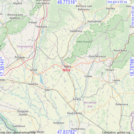
Nitra GPS coordinates[2]
48° 18' 27.468" North, 18° 5' 4.308" East
| Map corner | latitude | longitude |
|---|---|---|
| Upper-left | 48.77316°, | 17.38141° |
| Center: | 48.30763°, | 18.08453° |
| Lower-right: | 47.83782°, | 18.78766° |
| Map W x H: | 104×104 km | = 64.6×64.6mi |
| max Lat: | 49.43503° ⇑80% North |
| Nitra: | 48.30763° |
| min Lat: | ⇓20% South 47.76356° |
| min Long | Nitra | max Long |
| 16.9786° | 18.08453° | 22.18136° |
| W 22.4%⇐ | ⇒77.6% E |
Elevation
Elevation of Nitra is 144 m = 472 ft, and this is 192.1 m = 630 ft below average elevation for this country.
| Max E: |
1006 m = 3301 ft | 82.4% |
| Avg. | 336.1 m = 1103 ft | |
| Nitra | 144 m = 472 ft | |
Min E: |
102 m = 335 ft | 17.6% |
See also: Nitra elevation on elevation.city.
Geographical zone
Nitra is located in North temperate zone (between Tropic of Cancer and the Arctic Circle). Distance of this North polar circle is 2029.9 km =1261.3 mi to North.| Distance of | km | miles | from Nitra |
|---|---|---|---|
| North Pole | 4635.8 | 2880.6 | to North |
| Arctic Circle | 2029.9 | 1261.3 | to North |
| Tropic Cancer | 2765.4 | 1718.3 | to South |
| Equator | 5371.3 | 3337.6 | to South |


Nearby cities:
15 places around Nitra: (largest is in red/bold)
• Galanta
29.5 km =18.3 mi,  243°
243°
• Hlohovec
25 km =15.5 mi,  303°
303°
• Komárno
27.3 km =17 mi,  140°
140°
• Leopoldov
28.2 km =17.5 mi, 303°
• Levice
40 km =24.9 mi,  104°
104°
• Nové Zámky
36.3 km =22.6 mi,  170°
170°
• Piešťany
37.2 km =23.1 mi,  329°
329°
• Sládkovičovo
35.1 km =21.8 mi,  250°
250°
• Tlmače
33.1 km =20.6 mi,  93°
93°
• Topoľčany
29.1 km =18.1 mi,  12°
12°
• Trnava
37.6 km =23.4 mi,  281°
281°
• Vráble
18 km =11.2 mi,  113°
113°
• Zlaté Moravce
24.9 km =15.5 mi,  69°
69°
• Šaľa
23 km =14.3 mi,  220°
220°
• Šurany
25.7 km =16 mi,  163°
163°
Sources, notices
• [Note1] Compared only with cities in Slovakia existing in our database
• [Src1] Map data: © OpenStreetMap contributors (CC-BY-SA)
• [Src2] Other city data from geonames.org with taken over terms of usage.
• [Src3] Geographical zone / Annual Mean Temperature by Robert A. Rohde @ Wikipedia
