Štúrovo geodata
Štúrovo (Nitriansky kraj) is a populated place; located in Slovakia in Europe/Bratislava (GMT+2) time zone. With population of 11,708 people, there are 61 cities with bigger population in this country. Compared to other cities in Slovakia, 99.4% of cities are located further ↑North; 58.8% of cities are located further →East and 97.6% of cities have higher elevation than Štúrovo. Note1


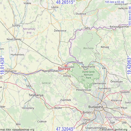
Štúrovo GPS coordinates[2]
47° 47' 41.82" North, 18° 43' 3" East
| Map corner | latitude | longitude |
|---|---|---|
| Upper-left | 48.26515°, | 18.01438° |
| Center: | 47.79495°, | 18.7175° |
| Lower-right: | 47.32045°, | 19.42063° |
| Map W x H: | 105×105 km | = 65.2×65.2mi |
| max Lat: | 49.43503° ⇑99.4% North |
| Štúrovo: | 47.79495° |
| min Lat: | ⇓0.6% South 47.76356° |
| min Long | Štúrovo | max Long |
| 16.9786° | 18.7175° | 22.18136° |
| W 41.2%⇐ | ⇒58.8% E |
Elevation
Elevation of Štúrovo is 110 m = 361 ft, and this is 226.1 m = 742 ft below average elevation for this country.
| Max E: |
1006 m = 3301 ft | 97.6% |
| Avg. | 336.1 m = 1103 ft | |
| Štúrovo | 110 m = 361 ft | |
Min E: |
102 m = 335 ft | 2.4% |
See also: Slovakia elevation on elevation.city.
Geographical zone
Štúrovo is located in North temperate zone (between Tropic of Cancer and the Arctic Circle). Distance of this North polar circle is 2086.9 km =1296.7 mi to North.| Distance of | km | miles | from Štúrovo |
|---|---|---|---|
| North Pole | 4692.8 | 2916 | to North |
| Arctic Circle | 2086.9 | 1296.7 | to North |
| Tropic Cancer | 2708.4 | 1682.9 | to South |
| Equator | 5314.3 | 3302.2 | to South |


Nearby cities:
15 places around Štúrovo: (largest is in red/bold)
• Dudince
43.7 km =27.2 mi,  16°
16°
• Hurbanovo
40.1 km =24.9 mi,  281°
281°
• Kolárovo
56.5 km =35.1 mi, 284°
• Komárno
44.6 km =27.7 mi,  265°
265°
• Komárno
46.6 km =29 mi,  320°
320°
• Levice
47.5 km =29.5 mi,  350°
350°
• Nové Zámky
46.5 km =28.9 mi,  297°
297°
• Svodín
20.7 km =12.9 mi,  308°
308°
• Tlmače
56.7 km =35.2 mi, 345°
• Veľký Krtíš
66 km =41 mi,  45°
45°
• Vráble
58.4 km =36.3 mi,  328°
328°
• Vágfüzes
50.1 km =31.1 mi, 277°
• Šahy
35.5 km =22.1 mi,  29°
29°
• Šurany
51.2 km =31.8 mi, 309°
• Želiezovce
28.8 km =17.9 mi, 350°
Sources, notices
• [Note1] Compared only with cities in Slovakia existing in our database
• [Src1] Map data: © OpenStreetMap contributors (CC-BY-SA)
• [Src2] Other city data from geonames.org with taken over terms of usage.
• [Src3] Geographical zone / Annual Mean Temperature by Robert A. Rohde @ Wikipedia
