Veľký Krtíš geodata
Veľký Krtíš (Banskobystrický kraj) is a seat of a second-order administrative division; located in Slovakia in Europe/Bratislava (GMT+2) time zone. With population of 12,608 people, there are 56 cities with bigger population in this country. Compared to other cities in Slovakia, 85.9% of cities are located further ↑North; 57.1% of cities are located further ←West and 59.4% of cities have higher elevation than Veľký Krtíš. Note1
Administrative division(s):
- Level 1: Banskobystrický kraj
- Level 2: Okres Veľký Krtíš
- Level 3: Veľký Krtíš


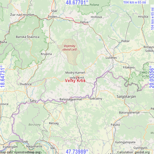
Veľký Krtíš GPS coordinates[2]
48° 12' 38.124" North, 19° 21' 1.548" East
| Map corner | latitude | longitude |
|---|---|---|
| Upper-left | 48.67701°, | 18.64731° |
| Center: | 48.21059°, | 19.35043° |
| Lower-right: | 47.73989°, | 20.05356° |
| Map W x H: | 104.2×104.2 km | = 64.7×64.7mi |
| max Lat: | 49.43503° ⇑85.9% North |
| Veľký Krtíš: | 48.21059° |
| min Lat: | ⇓14.1% South 47.76356° |
| min Long | Veľký Krtíš | max Long |
| 16.9786° | 19.35043° | 22.18136° |
| W 57.1%⇐ | ⇒42.9% E |
Elevation
Elevation of Veľký Krtíš is 218 m = 715 ft, and this is 118.1 m = 387 ft below average elevation for this country.
| Max E: |
1006 m = 3301 ft | 59.4% |
| Avg. | 336.1 m = 1103 ft | |
| Veľký Krtíš | 218 m = 715 ft | |
Min E: |
102 m = 335 ft | 40.6% |
See also: Slovakia elevation on elevation.city.
Geographical zone
Veľký Krtíš is located in North temperate zone (between Tropic of Cancer and the Arctic Circle). Distance of this North polar circle is 2040.7 km =1268 mi to North.| Distance of | km | miles | from Veľký Krtíš |
|---|---|---|---|
| North Pole | 4646.5 | 2887.2 | to North |
| Arctic Circle | 2040.7 | 1268 | to North |
| Tropic Cancer | 2754.6 | 1711.6 | to South |
| Equator | 5360.5 | 3330.9 | to South |


Nearby cities:
15 places around Veľký Krtíš: (largest is in red/bold)
• Banská Štiavnica
42 km =26.1 mi,  309°
309°
• Detva
39.3 km =24.4 mi,  7°
7°
• Dudince
34.6 km =21.5 mi,  262°
262°
• Fiľakovo
35.7 km =22.2 mi,  79°
79°
• Hriňová
42.8 km =26.6 mi,  17°
17°
• Hrochoť,Slovakia
49.6 km =30.8 mi,  356°
356°
• Kováčová
47.2 km =29.3 mi,  337°
337°
• Krupina
26.6 km =16.5 mi, 307°
• Lučenec
27.1 km =16.8 mi,  59°
59°
• Poltár
40.9 km =25.4 mi,  53°
53°
• Rimavská Sobota
53.3 km =33.1 mi,  68°
68°
• Svätý Anton
38.2 km =23.7 mi, 307°
• Zvolen
43 km =26.7 mi, 340°
• Šahy
33.4 km =20.8 mi,  242°
242°
• Želiezovce
54.6 km =33.9 mi,  251°
251°
Sources, notices
• [Note1] Compared only with cities in Slovakia existing in our database
• [Src1] Map data: © OpenStreetMap contributors (CC-BY-SA)
• [Src2] Other city data from geonames.org with taken over terms of usage.
• [Src3] Geographical zone / Annual Mean Temperature by Robert A. Rohde @ Wikipedia
