Šahy geodata
Šahy (Nitriansky kraj) is a populated place; located in Slovakia in Europe/Bratislava (GMT+2) time zone. With population of 8,061 people, there are 80 cities with bigger population in this country. Compared to other cities in Slovakia, 92.9% of cities are located further ↑North; 50% of cities are located further ←West and 84.1% of cities have higher elevation than Šahy. Note1


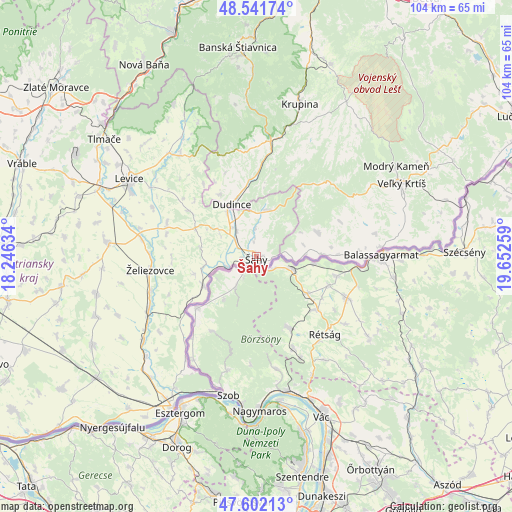
Šahy GPS coordinates[2]
48° 4' 26.688" North, 18° 56' 58.056" East
| Map corner | latitude | longitude |
|---|---|---|
| Upper-left | 48.54174°, | 18.24634° |
| Center: | 48.07408°, | 18.94946° |
| Lower-right: | 47.60213°, | 19.65259° |
| Map W x H: | 104.5×104.5 km | = 64.9×64.9mi |
| max Lat: | 49.43503° ⇑92.9% North |
| Šahy: | 48.07408° |
| min Lat: | ⇓7.1% South 47.76356° |
| min Long | Šahy | max Long |
| 16.9786° | 18.94946° | 22.18136° |
| W 50%⇐ | ⇒50% E |
Elevation
Elevation of Šahy is 143 m = 469 ft, and this is 193.1 m = 634 ft below average elevation for this country.
| Max E: |
1006 m = 3301 ft | 84.1% |
| Avg. | 336.1 m = 1103 ft | |
| Šahy | 143 m = 469 ft | |
Min E: |
102 m = 335 ft | 15.9% |
See also: Slovakia elevation on elevation.city.
Geographical zone
Šahy is located in North temperate zone (between Tropic of Cancer and the Arctic Circle). Distance of this North polar circle is 2055.8 km =1277.4 mi to North.| Distance of | km | miles | from Šahy |
|---|---|---|---|
| North Pole | 4661.7 | 2896.6 | to North |
| Arctic Circle | 2055.8 | 1277.4 | to North |
| Tropic Cancer | 2739.4 | 1702.2 | to South |
| Equator | 5345.3 | 3321.4 | to South |


Nearby cities:
15 places around Šahy: (largest is in red/bold)
• Banská Štiavnica
41.7 km =25.9 mi,  355°
355°
• Dudince
11.7 km =7.3 mi,  337°
337°
• Komárno
47.2 km =29.3 mi,  275°
275°
• Krupina
32.4 km =20.1 mi,  15°
15°
• Levice
29.9 km =18.6 mi,  301°
301°
• Nová Baňa
45 km =28 mi,  329°
329°
• Svodín
38.1 km =23.7 mi,  241°
241°
• Svätý Anton
38.4 km =23.9 mi, 358°
• Tlmače
39.1 km =24.3 mi,  307°
307°
• Veľký Krtíš
33.4 km =20.8 mi,  62°
62°
• Voznica
46.8 km =29.1 mi, 336°
• Vráble
51.1 km =31.8 mi,  291°
291°
• Štúrovo
35.5 km =22.1 mi,  209°
209°
• Žarnovica
48.5 km =30.1 mi, 339°
• Želiezovce
22.1 km =13.7 mi,  263°
263°
Sources, notices
• [Note1] Compared only with cities in Slovakia existing in our database
• [Src1] Map data: © OpenStreetMap contributors (CC-BY-SA)
• [Src2] Other city data from geonames.org with taken over terms of usage.
• [Src3] Geographical zone / Annual Mean Temperature by Robert A. Rohde @ Wikipedia
