Levoča geodata
Levoča (Prešovský kraj) is a seat of a second-order administrative division; located in Slovakia in Europe/Bratislava (GMT+2) time zone. With population of 14,511 people, there are 53 cities with bigger population in this country. Compared to other cities in Slovakia, 67.6% of cities are located further ↓South; 82.9% of cities are located further ←West and 81.2% of cities have lower elevation than Levoča. Note1


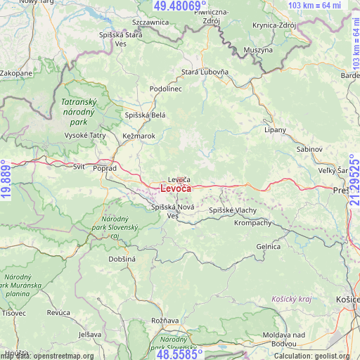
Levoča GPS coordinates[2]
49° 1' 18.228" North, 20° 35' 31.632" East
| Map corner | latitude | longitude |
|---|---|---|
| Upper-left | 49.48069°, | 19.889° |
| Center: | 49.02173°, | 20.59212° |
| Lower-right: | 48.5585°, | 21.29525° |
| Map W x H: | 102.5×102.5 km | = 63.7×63.7mi |
| max Lat: | 49.43503° ⇑32.4% North |
| Levoča: | 49.02173° |
| min Lat: | ⇓67.6% South 47.76356° |
| min Long | Levoča | max Long |
| 16.9786° | 20.59212° | 22.18136° |
| W 82.9%⇐ | ⇒17.1% E |
Elevation
Elevation of Levoča is 536 m = 1759 ft, and this is 199.9 m = 656 ft above average elevation for this country.
| Max E: |
1006 m = 3301 ft | 18.8% |
| Levoča | 536 m 1759 ft | |
| Avg. | 336.1 m = 1103 ft | |
Min E: |
102 m = 335 ft | 81.2% |
See also: Slovakia elevation on elevation.city.
Geographical zone
Levoča is located in North temperate zone (between Tropic of Cancer and the Arctic Circle). Distance of this North polar circle is 1950.5 km =1212 mi to North.| Distance of | km | miles | from Levoča |
|---|---|---|---|
| North Pole | 4556.4 | 2831.2 | to North |
| Arctic Circle | 1950.5 | 1212 | to North |
| Tropic Cancer | 2844.8 | 1767.7 | to South |
| Equator | 5450.7 | 3386.9 | to South |


Nearby cities:
15 places around Levoča: (largest is in red/bold)
• Bijacovce
15.1 km =9.4 mi,  89°
89°
• Dobšiná
27.6 km =17.1 mi,  215°
215°
• Kežmarok
17.1 km =10.6 mi,  317°
317°
• Krompachy
23.9 km =14.9 mi,  119°
119°
• Nová Lesná
26.2 km =16.3 mi,  295°
295°
• Podolínec
26.7 km =16.6 mi,  351°
351°
• Poprad
21.9 km =13.6 mi,  281°
281°
• Spišská Belá
20.8 km =12.9 mi,  332°
332°
• Spišská Nová Ves
8.9 km =5.5 mi,  194°
194°
• Spišské Podhradie
12 km =7.5 mi,  101°
101°
• Svit
28.4 km =17.6 mi, 278°
• Tatranská Lomnica
27.8 km =17.3 mi,  305°
305°
• Vrbov
14.2 km =8.8 mi, 301°
• Ľubica
14.8 km =9.2 mi, 315°
• Žehra
15.3 km =9.5 mi,  107°
107°
Sources, notices
• [Note1] Compared only with cities in Slovakia existing in our database
• [Src1] Map data: © OpenStreetMap contributors (CC-BY-SA)
• [Src2] Other city data from geonames.org with taken over terms of usage.
• [Src3] Geographical zone / Annual Mean Temperature by Robert A. Rohde @ Wikipedia
