Bijacovce geodata
Bijacovce (Prešovský kraj) is a populated place; located in Slovakia in Europe/Bratislava (GMT+2) time zone. With population of 955 people, there are 154 cities with bigger population in this country. Compared to other cities in Slovakia, 68.2% of cities are located further ↓South; 85.3% of cities are located further ←West and 78.8% of cities have lower elevation than Bijacovce. Note1


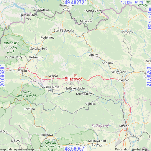
Bijacovce GPS coordinates[2]
49° 1' 25.608" North, 20° 47' 57.84" East
| Map corner | latitude | longitude |
|---|---|---|
| Upper-left | 49.48272°, | 20.09628° |
| Center: | 49.02378°, | 20.7994° |
| Lower-right: | 48.56057°, | 21.50253° |
| Map W x H: | 102.5×102.5 km | = 63.7×63.7mi |
| max Lat: | 49.43503° ⇑31.8% North |
| Bijacovce: | 49.02378° |
| min Lat: | ⇓68.2% South 47.76356° |
| min Long | Bijacovce | max Long |
| 16.9786° | 20.7994° | 22.18136° |
| W 85.3%⇐ | ⇒14.7% E |
Elevation
Elevation of Bijacovce is 519 m = 1703 ft, and this is 182.9 m = 600 ft above average elevation for this country.
| Max E: |
1006 m = 3301 ft | 21.2% |
| Bijacovce | 519 m 1703 ft | |
| Avg. | 336.1 m = 1103 ft | |
Min E: |
102 m = 335 ft | 78.8% |
See also: Slovakia elevation on elevation.city.
Geographical zone
Bijacovce is located in North temperate zone (between Tropic of Cancer and the Arctic Circle). Distance of this North polar circle is 1950.2 km =1211.8 mi to North.| Distance of | km | miles | from Bijacovce |
|---|---|---|---|
| North Pole | 4556.1 | 2831 | to North |
| Arctic Circle | 1950.2 | 1211.8 | to North |
| Tropic Cancer | 2845 | 1767.8 | to South |
| Equator | 5450.9 | 3387 | to South |


Nearby cities:
15 places around Bijacovce: (largest is in red/bold)
• Gelnica
21.2 km =13.2 mi,  151°
151°
• Kežmarok
29.4 km =18.3 mi,  295°
295°
• Krompachy
13.4 km =8.3 mi,  155°
155°
• Levoča
15.1 km =9.4 mi,  269°
269°
• Lipany
18.8 km =11.7 mi,  39°
39°
• Podolínec
32.4 km =20.1 mi,  323°
323°
• Prešov
31.8 km =19.8 mi,  95°
95°
• Sabinov
23.5 km =14.6 mi,  67°
67°
• Spišská Belá
30.7 km =19.1 mi,  306°
306°
• Spišská Nová Ves
19.5 km =12.1 mi,  243°
243°
• Spišské Podhradie
4.2 km =2.6 mi,  232°
232°
• Stará Ľubovňa
31.6 km =19.6 mi,  344°
344°
• Vrbov
28.2 km =17.5 mi,  284°
284°
• Ľubica
27.5 km =17.1 mi,  292°
292°
• Žehra
4.9 km =3 mi,  186°
186°
Sources, notices
• [Note1] Compared only with cities in Slovakia existing in our database
• [Src1] Map data: © OpenStreetMap contributors (CC-BY-SA)
• [Src2] Other city data from geonames.org with taken over terms of usage.
• [Src3] Geographical zone / Annual Mean Temperature by Robert A. Rohde @ Wikipedia
