Podolínec geodata
Podolínec (Prešovský kraj) is a populated place; located in Slovakia in Europe/Bratislava (GMT+2) time zone. With population of 3,173 people, there are 133 cities with bigger population in this country. Compared to other cities in Slovakia, 90% of cities are located further ↓South; 80.6% of cities are located further ←West and 84.1% of cities have lower elevation than Podolínec. Note1


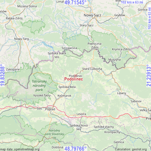
Podolínec GPS coordinates[2]
49° 15' 31.284" North, 20° 32' 9.6" East
| Map corner | latitude | longitude |
|---|---|---|
| Upper-left | 49.71545°, | 19.83288° |
| Center: | 49.25869°, | 20.536° |
| Lower-right: | 48.79766°, | 21.23913° |
| Map W x H: | 102×102 km | = 63.4×63.4mi |
| max Lat: | 49.43503° ⇑10% North |
| Podolínec: | 49.25869° |
| min Lat: | ⇓90% South 47.76356° |
| min Long | Podolínec | max Long |
| 16.9786° | 20.536° | 22.18136° |
| W 80.6%⇐ | ⇒19.4% E |
Elevation
Elevation of Podolínec is 567 m = 1860 ft, and this is 230.9 m = 758 ft above average elevation for this country.
| Max E: |
1006 m = 3301 ft | 15.9% |
| Podolínec | 567 m 1860 ft | |
| Avg. | 336.1 m = 1103 ft | |
Min E: |
102 m = 335 ft | 84.1% |
See also: Slovakia elevation on elevation.city.
Geographical zone
Podolínec is located in North temperate zone (between Tropic of Cancer and the Arctic Circle). Distance of this North polar circle is 1924.1 km =1195.6 mi to North.| Distance of | km | miles | from Podolínec |
|---|---|---|---|
| North Pole | 4530 | 2814.8 | to North |
| Arctic Circle | 1924.1 | 1195.6 | to North |
| Tropic Cancer | 2871.1 | 1784 | to South |
| Equator | 5477.1 | 3403.3 | to South |


Nearby cities:
15 places around Podolínec: (largest is in red/bold)
• Bijacovce
32.4 km =20.1 mi,  143°
143°
• Kežmarok
15.6 km =9.7 mi,  208°
208°
• Levoča
26.7 km =16.6 mi,  171°
171°
• Nová Lesná
24.7 km =15.3 mi,  232°
232°
• Poprad
27.9 km =17.3 mi,  218°
218°
• Spišská Belá
9.7 km =6 mi, 214°
• Stará Ľubovňa
11.8 km =7.3 mi,  67°
67°
• Starý Smokovec
26.5 km =16.5 mi,  239°
239°
• Svit
32.6 km =20.3 mi, 227°
• Tatranská Lomnica
21.2 km =13.2 mi, 240°
• Vrbov
20.7 km =12.9 mi,  202°
202°
• Vysoké Tatry
25.2 km =15.7 mi, 237°
• Vyšné Ružbachy
5.5 km =3.4 mi,  23°
23°
• Ľubica
17 km =10.6 mi, 201°
• Ždiar
19.9 km =12.4 mi,  273°
273°
Sources, notices
• [Note1] Compared only with cities in Slovakia existing in our database
• [Src1] Map data: © OpenStreetMap contributors (CC-BY-SA)
• [Src2] Other city data from geonames.org with taken over terms of usage.
• [Src3] Geographical zone / Annual Mean Temperature by Robert A. Rohde @ Wikipedia
