Žehra geodata
Žehra (Košický kraj) is a seat of a third-order administrative division; located in Slovakia in Europe/Bratislava (GMT+2) time zone. With population of 2,360 people, there are 135 cities with bigger population in this country. Compared to other cities in Slovakia, 64.7% of cities are located further ↓South; 84.7% of cities are located further ←West and 68.2% of cities have lower elevation than Žehra. Note1


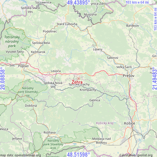
Žehra GPS coordinates[2]
48° 58' 46.56" North, 20° 47' 30.12" East
| Map corner | latitude | longitude |
|---|---|---|
| Upper-left | 49.43895°, | 20.08858° |
| Center: | 48.9796°, | 20.7917° |
| Lower-right: | 48.51598°, | 21.49483° |
| Map W x H: | 102.6×102.6 km | = 63.8×63.8mi |
| max Lat: | 49.43503° ⇑35.3% North |
| Žehra: | 48.9796° |
| min Lat: | ⇓64.7% South 47.76356° |
| min Long | Žehra | max Long |
| 16.9786° | 20.7917° | 22.18136° |
| W 84.7%⇐ | ⇒15.3% E |
Elevation
Elevation of Žehra is 418 m = 1371 ft, and this is 81.9 m = 269 ft above average elevation for this country.
| Max E: |
1006 m = 3301 ft | 31.8% |
| Žehra | 418 m 1371 ft | |
| Avg. | 336.1 m = 1103 ft | |
Min E: |
102 m = 335 ft | 68.2% |
See also: Slovakia elevation on elevation.city.
Geographical zone
Žehra is located in North temperate zone (between Tropic of Cancer and the Arctic Circle). Distance of this North polar circle is 1955.2 km =1214.9 mi to North.| Distance of | km | miles | from Žehra |
|---|---|---|---|
| North Pole | 4561 | 2834.1 | to North |
| Arctic Circle | 1955.2 | 1214.9 | to North |
| Tropic Cancer | 2840.1 | 1764.8 | to South |
| Equator | 5446 | 3384 | to South |


Nearby cities:
15 places around Žehra: (largest is in red/bold)
• Bijacovce
4.9 km =3 mi,  6°
6°
• Dobšiná
35.5 km =22.1 mi,  240°
240°
• Gelnica
17.4 km =10.8 mi,  142°
142°
• Kežmarok
31.3 km =19.4 mi,  303°
303°
• Krompachy
9.5 km =5.9 mi, 139°
• Levoča
15.3 km =9.5 mi,  287°
287°
• Lipany
23.1 km =14.4 mi,  32°
32°
• Medzev
31.9 km =19.8 mi,  166°
166°
• Prešov
32.3 km =20.1 mi,  86°
86°
• Sabinov
26.3 km =16.3 mi,  58°
58°
• Spišská Belá
33.4 km =20.8 mi,  313°
313°
• Spišská Nová Ves
17.2 km =10.7 mi,  256°
256°
• Spišské Podhradie
3.7 km =2.3 mi, 310°
• Vrbov
29.3 km =18.2 mi, 294°
• Ľubica
29.2 km =18.1 mi, 301°
Sources, notices
• [Note1] Compared only with cities in Slovakia existing in our database
• [Src1] Map data: © OpenStreetMap contributors (CC-BY-SA)
• [Src2] Other city data from geonames.org with taken over terms of usage.
• [Src3] Geographical zone / Annual Mean Temperature by Robert A. Rohde @ Wikipedia
