Palima geodata
Palima (Southern Province) is a populated place; located in Sierra Leone in Africa/Freetown (GMT+0) time zone. With population of 4,116 people, there are 54 cities with bigger population in this country. Compared to other cities in Sierra Leone, 65.1% of cities are located further ↑North; 59% of cities are located further ←West and 75.9% of cities have lower elevation than Palima. Note1


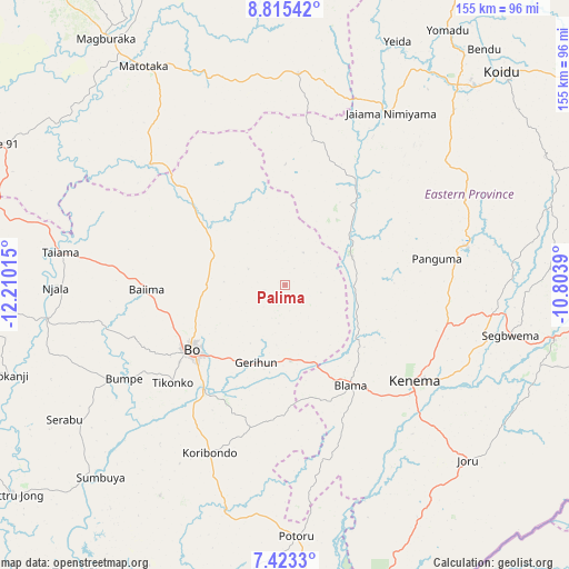
Palima GPS coordinates[2]
8° 7' 11.856" North, 11° 30' 25.272" West
| Map corner | latitude | longitude |
|---|---|---|
| Upper-left | 8.81542°, | -12.21015° |
| Center: | 8.11996°, | -11.50702° |
| Lower-right: | 7.4233°, | -10.8039° |
| Map W x H: | 154.8×154.8 km | = 96.2×96.2mi |
| max Lat: | 9.91376° ⇑65.1% North |
| Palima: | 8.11996° |
| min Lat: | ⇓34.9% South 7.24611° |
| min Long | Palima | max Long |
| -13.28972° | -11.50702° | -10.37135° |
| W 59%⇐ | ⇒41% E |
Elevation
Elevation of Palima is 253 m = 830 ft, and this is 95.8 m = 314 ft above average elevation for this country.
| Max E: |
564 m = 1850 ft | 24.1% |
| Palima | 253 m 830 ft | |
| Avg. | 157.2 m = 516 ft | |
Min E: |
1 m = 3 ft | 75.9% |
See also: Sierra Leone elevation on elevation.city.
Geographical zone
Palima is located in North Torrid zone (between Equator and Tropic of Cancer). Distance of Equator is 902.9 km =561 mi to South.| Distance of | km | miles | from Palima |
|---|---|---|---|
| North Pole | 9104.2 | 5657.1 | to North |
| Arctic Circle | 6498.3 | 4037.9 | to North |
| Tropic Cancer | 1703.1 | 1058.3 | to North |
| Equator | 902.9 | 561 | to South |


Nearby cities:
15 places around Palima: (largest is in red/bold)
• Baiima
37.5 km =23.3 mi,  268°
268°
• Baoma
26.8 km =16.7 mi,  238°
238°
• Barma
32.1 km =19.9 mi,  37°
37°
• Blama
32.5 km =20.2 mi,  146°
146°
• Bo
30.8 km =19.1 mi, 235°
• Boajibu
19.8 km =12.3 mi,  67°
67°
• Bumpe
50.7 km =31.5 mi, 239°
• Giehun
56.8 km =35.3 mi,  117°
117°
• Hangha
45 km =28 mi, 116°
• Kenema
44.1 km =27.4 mi,  127°
127°
• Koribundu
50 km =31.1 mi,  204°
204°
• Makali
59.2 km =36.8 mi,  343°
343°
• Mamboma
20.3 km =12.6 mi,  259°
259°
• Panguma
41.8 km =26 mi,  80°
80°
• Wima
38.9 km =24.2 mi,  58°
58°
Sources, notices
• [Note1] Compared only with cities in Sierra Leone existing in our database
• [Src1] Map data: © OpenStreetMap contributors (CC-BY-SA)
• [Src2] Other city data from geonames.org with taken over terms of usage.
• [Src3] Geographical zone / Annual Mean Temperature by Robert A. Rohde @ Wikipedia
