Barma geodata
Barma (Eastern Province) is a populated place; located in Sierra Leone in Africa/Freetown (GMT+0) time zone. With population of 7,529 people, there are 27 cities with bigger population in this country. Compared to other cities in Sierra Leone, 51.8% of cities are located further ↓South; 66.3% of cities are located further ←West and 61.4% of cities have lower elevation than Barma. Note1


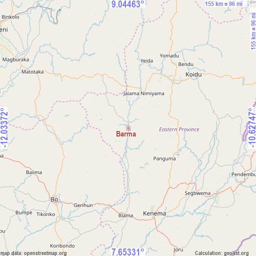
Barma GPS coordinates[2]
8° 20' 58.524" North, 11° 19' 50.124" West
| Map corner | latitude | longitude |
|---|---|---|
| Upper-left | 9.04463°, | -12.03372° |
| Center: | 8.34959°, | -11.33059° |
| Lower-right: | 7.65331°, | -10.62747° |
| Map W x H: | 154.7×154.7 km | = 96.1×96.1mi |
| max Lat: | 9.91376° ⇑48.2% North |
| Barma: | 8.34959° |
| min Lat: | ⇓51.8% South 7.24611° |
| min Long | Barma | max Long |
| -13.28972° | -11.33059° | -10.37135° |
| W 66.3%⇐ | ⇒33.7% E |
Elevation
Elevation of Barma is 148 m = 486 ft, and this is 9.2 m = 30 ft below average elevation for this country.
| Max E: |
564 m = 1850 ft | 38.6% |
| Avg. | 157.2 m = 516 ft | |
| Barma | 148 m = 486 ft | |
Min E: |
1 m = 3 ft | 61.4% |
See also: Sierra Leone elevation on elevation.city.
Geographical zone
Barma is located in North Torrid zone (between Equator and Tropic of Cancer). Distance of Equator is 928.4 km =576.9 mi to South.| Distance of | km | miles | from Barma |
|---|---|---|---|
| North Pole | 9078.7 | 5641.2 | to North |
| Arctic Circle | 6472.8 | 4022 | to North |
| Tropic Cancer | 1677.5 | 1042.3 | to North |
| Equator | 928.4 | 576.9 | to South |


Nearby cities:
15 places around Barma: (largest is in red/bold)
• Blama
52.8 km =32.8 mi,  181°
181°
• Boajibu
18 km =11.2 mi, 183°
• Giehun
39 km =24.2 mi,  54°
54°
• Hangha
50.1 km =31.1 mi,  155°
155°
• Koidu
51.3 km =31.9 mi, 50°
• Koyima
52.1 km =32.4 mi,  40°
40°
• Makali
47.9 km =29.8 mi,  310°
310°
• Mamboma
49 km =30.4 mi,  233°
233°
• Motema
45.7 km =28.4 mi, 49°
• Palima
32.1 km =19.9 mi,  217°
217°
• Panguma
28.4 km =17.6 mi,  130°
130°
• Simbakoro
46 km =28.6 mi, 50°
• Tefeya
41.5 km =25.8 mi,  18°
18°
• Wima
14.9 km =9.3 mi,  111°
111°
• Yengema
44.2 km =27.5 mi, 23°
Sources, notices
• [Note1] Compared only with cities in Sierra Leone existing in our database
• [Src1] Map data: © OpenStreetMap contributors (CC-BY-SA)
• [Src2] Other city data from geonames.org with taken over terms of usage.
• [Src3] Geographical zone / Annual Mean Temperature by Robert A. Rohde @ Wikipedia
