Blama geodata
Blama (Eastern Province) is a populated place; located in Sierra Leone in Africa/Freetown (GMT+0) time zone. With population of 8,146 people, there are 22 cities with bigger population in this country. Compared to other cities in Sierra Leone, 81.9% of cities are located further ↑North; 63.9% of cities are located further ←West and 55.4% of cities have lower elevation than Blama. Note1


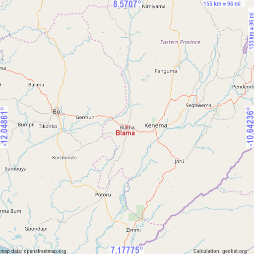
Blama GPS coordinates[2]
7° 52' 29.316" North, 11° 20' 43.728" West
| Map corner | latitude | longitude |
|---|---|---|
| Upper-left | 8.5707°, | -12.04861° |
| Center: | 7.87481°, | -11.34548° |
| Lower-right: | 7.17775°, | -10.64236° |
| Map W x H: | 154.9×154.9 km | = 96.3×96.3mi |
| max Lat: | 9.91376° ⇑81.9% North |
| Blama: | 7.87481° |
| min Lat: | ⇓18.1% South 7.24611° |
| min Long | Blama | max Long |
| -13.28972° | -11.34548° | -10.37135° |
| W 63.9%⇐ | ⇒36.1% E |
Elevation
Elevation of Blama is 122 m = 400 ft, and this is 35.2 m = 115 ft below average elevation for this country.
| Max E: |
564 m = 1850 ft | 44.6% |
| Avg. | 157.2 m = 516 ft | |
| Blama | 122 m = 400 ft | |
Min E: |
1 m = 3 ft | 55.4% |
See also: Sierra Leone elevation on elevation.city.
Geographical zone
Blama is located in North Torrid zone (between Equator and Tropic of Cancer). Distance of Equator is 875.6 km =544.1 mi to South.| Distance of | km | miles | from Blama |
|---|---|---|---|
| North Pole | 9131.5 | 5674 | to North |
| Arctic Circle | 6525.6 | 4054.8 | to North |
| Tropic Cancer | 1730.3 | 1075.2 | to North |
| Equator | 875.6 | 544.1 | to South |


Nearby cities:
15 places around Blama: (largest is in red/bold)
• Baoma
42.7 km =26.5 mi,  287°
287°
• Bo
44.4 km =27.6 mi,  283°
283°
• Boajibu
34.8 km =21.6 mi,  0°
0°
• Gbewebu
46.2 km =28.7 mi,  218°
218°
• Giehun
32.7 km =20.3 mi,  88°
88°
• Gorahun
47.1 km =29.3 mi,  165°
165°
• Hangha
23.6 km =14.7 mi,  72°
72°
• Kenema
17.1 km =10.6 mi, 89°
• Koribundu
42.5 km =26.4 mi,  244°
244°
• Mamboma
44.6 km =27.7 mi,  302°
302°
• Palima
32.5 km =20.2 mi,  326°
326°
• Panguma
41.7 km =25.9 mi,  34°
34°
• Potoru
43.6 km =27.1 mi,  199°
199°
• Segbwema
45.5 km =28.3 mi, 72°
• Wima
49.8 km =30.9 mi,  18°
18°
Sources, notices
• [Note1] Compared only with cities in Sierra Leone existing in our database
• [Src1] Map data: © OpenStreetMap contributors (CC-BY-SA)
• [Src2] Other city data from geonames.org with taken over terms of usage.
• [Src3] Geographical zone / Annual Mean Temperature by Robert A. Rohde @ Wikipedia
