Pout geodata
Pout (Thiès) is a populated place; located in Senegal in Africa/Dakar (GMT+0) time zone. With population of 17,752 people, there are 27 cities with bigger population in this country. Compared to other cities in Senegal, 60% of cities are located further ↓South; 91.7% of cities are located further →East and 68.3% of cities have lower elevation than Pout. Note1


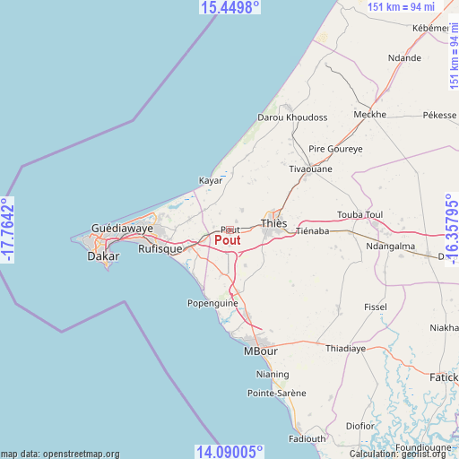
Pout GPS coordinates[2]
14° 46' 15.564" North, 17° 3' 39.852" West
| Map corner | latitude | longitude |
|---|---|---|
| Upper-left | 15.4498°, | -17.7642° |
| Center: | 14.77099°, | -17.06107° |
| Lower-right: | 14.09005°, | -16.35795° |
| Map W x H: | 151.2×151.2 km | = 94×94mi |
| max Lat: | 16.51293° ⇑40% North |
| Pout: | 14.77099° |
| min Lat: | ⇓60% South 12.485° |
| min Long | Pout | max Long |
| -17.47581° | -17.06107° | -12.18076° |
| W 8.3%⇐ | ⇒91.7% E |
Elevation
Elevation of Pout is 25 m = 82 ft, and this is 0.5 m = 2 ft above average elevation for this country.
| Max E: |
127 m = 417 ft | 31.7% |
| Pout | 25 m 82 ft | |
| Avg. | 24.5 m = 80 ft | |
Min E: |
0 m = 0 ft | 68.3% |
See also: Senegal elevation on elevation.city.
Geographical zone
Pout is located in North Torrid zone (between Equator and Tropic of Cancer). Distance of this Northern Tropic circle is 963.5 km =598.7 mi to North.| Distance of | km | miles | from Pout |
|---|---|---|---|
| North Pole | 8364.7 | 5197.6 | to North |
| Arctic Circle | 5758.8 | 3578.4 | to North |
| Tropic Cancer | 963.5 | 598.7 | to North |
| Equator | 1642.4 | 1020.5 | to South |


Nearby cities:
15 places around Pout: (largest is in red/bold)
• Dakar
42.1 km =26.2 mi,  258°
258°
• Diofior
77.9 km =48.4 mi,  146°
146°
• Joal-Fadiout
71.5 km =44.4 mi,  159°
159°
• Kayar
17.6 km =10.9 mi,  339°
339°
• Keur Babakar Toumbou
82.3 km =51.1 mi, 153°
• Khombole
38.8 km =24.1 mi,  90°
90°
• Mermoz Boabab
45.2 km =28.1 mi, 260°
• Mékhé
60.4 km =37.5 mi,  51°
51°
• Nguékhokh
29.4 km =18.3 mi,  168°
168°
• N’diareme limamoulaye
34.7 km =21.6 mi,  271°
271°
• Pikine
35.4 km =22 mi, 268°
• Thiès
14.7 km =9.1 mi,  81°
81°
• Thiès Nones
10.2 km =6.3 mi, 82°
• Tiadiaye
55.3 km =34.4 mi,  135°
135°
• Warang
46 km =28.6 mi, 164°
Sources, notices
• [Note1] Compared only with cities in Senegal existing in our database
• [Src1] Map data: © OpenStreetMap contributors (CC-BY-SA)
• [Src2] Other city data from geonames.org with taken over terms of usage.
• [Src3] Geographical zone / Annual Mean Temperature by Robert A. Rohde @ Wikipedia
