Mékhé geodata
Mékhé (Thiès) is a populated place; located in Senegal in Africa/Dakar (GMT+0) time zone. With population of 19,242 people, there are 24 cities with bigger population in this country. Compared to other cities in Senegal, 73.3% of cities are located further ↓South; 73.3% of cities are located further →East and 90% of cities have lower elevation than Mékhé. Note1


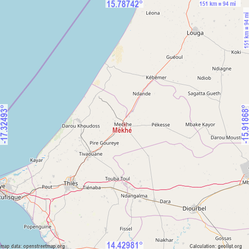
Mékhé GPS coordinates[2]
15° 6' 34.92" North, 16° 37' 18.48" West
| Map corner | latitude | longitude |
|---|---|---|
| Upper-left | 15.78742°, | -17.32493° |
| Center: | 15.1097°, | -16.6218° |
| Lower-right: | 14.42981°, | -15.91868° |
| Map W x H: | 151×151 km | = 93.8×93.8mi |
| max Lat: | 16.51293° ⇑26.7% North |
| Mékhé: | 15.1097° |
| min Lat: | ⇓73.3% South 12.485° |
| min Long | Mékhé | max Long |
| -17.47581° | -16.6218° | -12.18076° |
| W 26.7%⇐ | ⇒73.3% E |
Elevation
Elevation of Mékhé is 43 m = 141 ft, and this is 18.5 m = 61 ft above average elevation for this country.
| Max E: |
127 m = 417 ft | 10% |
| Mékhé | 43 m 141 ft | |
| Avg. | 24.5 m = 80 ft | |
Min E: |
0 m = 0 ft | 90% |
See also: Senegal elevation on elevation.city.
Geographical zone
Mékhé is located in North Torrid zone (between Equator and Tropic of Cancer). Distance of this Northern Tropic circle is 925.9 km =575.3 mi to North.| Distance of | km | miles | from Mékhé |
|---|---|---|---|
| North Pole | 8327 | 5174.2 | to North |
| Arctic Circle | 5721.1 | 3554.9 | to North |
| Tropic Cancer | 925.9 | 575.3 | to North |
| Equator | 1680 | 1043.9 | to South |


Nearby cities:
15 places around Mékhé: (largest is in red/bold)
• Diourbel
65.5 km =40.7 mi,  141°
141°
• Guéoul
50.8 km =31.6 mi,  35°
35°
• Kayar
57.5 km =35.7 mi,  248°
248°
• Khombole
39.1 km =24.3 mi,  192°
192°
• Louga
70.8 km =44 mi, 36°
• Mbaké
84.5 km =52.5 mi,  114°
114°
• Nguékhokh
78.1 km =48.5 mi,  211°
211°
• Pourham
87.3 km =54.2 mi,  165°
165°
• Pout
60.4 km =37.5 mi,  231°
231°
• Thiès
48.3 km =30 mi,  222°
222°
• Thiès Nones
51.9 km =32.2 mi, 225°
• Tiadiaye
77.5 km =48.2 mi, 186°
• Tiébo
67.4 km =41.9 mi, 141°
• Touba
84.4 km =52.4 mi, 110°
• Warang
88.9 km =55.2 mi,  202°
202°
Sources, notices
• [Note1] Compared only with cities in Senegal existing in our database
• [Src1] Map data: © OpenStreetMap contributors (CC-BY-SA)
• [Src2] Other city data from geonames.org with taken over terms of usage.
• [Src3] Geographical zone / Annual Mean Temperature by Robert A. Rohde @ Wikipedia
