Khombole geodata
Khombole (Thiès) is a populated place; located in Senegal in Africa/Dakar (GMT+0) time zone. With population of 12,061 people, there are 35 cities with bigger population in this country. Compared to other cities in Senegal, 58.3% of cities are located further ↓South; 78.3% of cities are located further →East and 63.3% of cities have higher elevation than Khombole. Note1


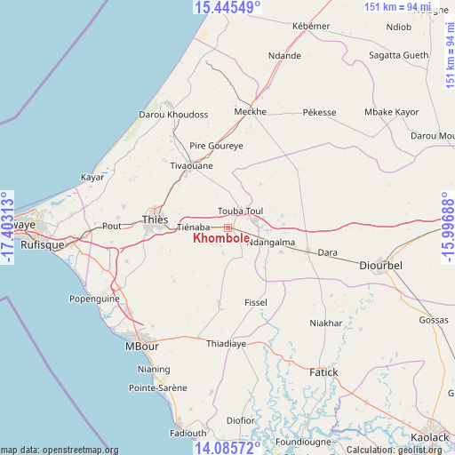
Khombole GPS coordinates[2]
14° 46' 0.012" North, 16° 42' 0" West
| Map corner | latitude | longitude |
|---|---|---|
| Upper-left | 15.44549°, | -17.40313° |
| Center: | 14.76667°, | -16.7° |
| Lower-right: | 14.08572°, | -15.99688° |
| Map W x H: | 151.2×151.2 km | = 94×94mi |
| max Lat: | 16.51293° ⇑41.7% North |
| Khombole: | 14.76667° |
| min Lat: | ⇓58.3% South 12.485° |
| min Long | Khombole | max Long |
| -17.47581° | -16.7° | -12.18076° |
| W 21.7%⇐ | ⇒78.3% E |
Elevation
Elevation of Khombole is 17 m = 56 ft, and this is 7.5 m = 25 ft below average elevation for this country.
| Max E: |
127 m = 417 ft | 63.3% |
| Avg. | 24.5 m = 80 ft | |
| Khombole | 17 m = 56 ft | |
Min E: |
0 m = 0 ft | 36.7% |
See also: Senegal elevation on elevation.city.
Geographical zone
Khombole is located in North Torrid zone (between Equator and Tropic of Cancer). Distance of this Northern Tropic circle is 964 km =599 mi to North.| Distance of | km | miles | from Khombole |
|---|---|---|---|
| North Pole | 8365.2 | 5197.9 | to North |
| Arctic Circle | 5759.3 | 3578.7 | to North |
| Tropic Cancer | 964 | 599 | to North |
| Equator | 1641.9 | 1020.2 | to South |


Nearby cities:
15 places around Khombole: (largest is in red/bold)
• Diofior
65 km =40.4 mi,  176°
176°
• Diourbel
50.8 km =31.6 mi,  105°
105°
• Fatick
57.8 km =35.9 mi,  146°
146°
• Joal-Fadiout
68.2 km =42.4 mi,  192°
192°
• Kayar
48.2 km =30 mi,  290°
290°
• Keur Babakar Toumbou
73.2 km =45.5 mi, 181°
• Mékhé
39.1 km =24.3 mi,  12°
12°
• Nguékhokh
43.3 km =26.9 mi,  229°
229°
• Pourham
55.5 km =34.5 mi, 146°
• Pout
38.8 km =24.1 mi,  270°
270°
• Thiès
24.4 km =15.2 mi,  275°
275°
• Thiès Nones
28.7 km =17.8 mi, 273°
• Tiadiaye
38.9 km =24.2 mi, 180°
• Tiébo
52.3 km =32.5 mi, 106°
• Warang
51 km =31.7 mi,  210°
210°
Sources, notices
• [Note1] Compared only with cities in Senegal existing in our database
• [Src1] Map data: © OpenStreetMap contributors (CC-BY-SA)
• [Src2] Other city data from geonames.org with taken over terms of usage.
• [Src3] Geographical zone / Annual Mean Temperature by Robert A. Rohde @ Wikipedia
