Thiès geodata
Thiès is a seat of a second-order administrative division; located in Senegal in Africa/Dakar (GMT+0) time zone. With population of 320,000 people, there are 3 cities with bigger population in this country. Compared to other cities in Senegal, 65% of cities are located further ↓South; 85% of cities are located further →East and 96.7% of cities have lower elevation than Thiès. Note1


Thiès GPS coordinates[2]
14° 47' 21.984" North, 16° 55' 33.672" West
| Map corner | latitude | longitude |
|---|---|---|
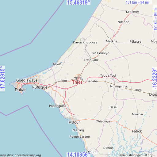
| Upper-left | 15.46819°, | -17.62915° |
| Center: | 14.78944°, | -16.92602° |
| Lower-right: | 14.10856°, | -16.2229° |
| Map W x H: | 151.2×151.2 km | = 94×94mi |
| max Lat: | 16.51293° ⇑35% North |
| Thiès: | 14.78944° |
| min Lat: | ⇓65% South 12.485° |
| min Long | Thiès | max Long |
| -17.47581° | -16.92602° | -12.18076° |
| W 15%⇐ | ⇒85% E |
Elevation
Elevation of Thiès is 72 m = 236 ft, and this is 47.5 m = 156 ft above average elevation for this country.
| Max E: |
127 m = 417 ft | 3.3% |
| Thiès | 72 m 236 ft | |
| Avg. | 24.5 m = 80 ft | |
Min E: |
0 m = 0 ft | 96.7% |
See also: Thiès elevation on elevation.city.
Geographical zone
Thiès is located in North Torrid zone (between Equator and Tropic of Cancer). Distance of this Northern Tropic circle is 961.5 km =597.4 mi to North.| Distance of | km | miles | from Thiès |
|---|---|---|---|
| North Pole | 8362.6 | 5196.3 | to North |
| Arctic Circle | 5756.7 | 3577 | to North |
| Tropic Cancer | 961.5 | 597.4 | to North |
| Equator | 1644.4 | 1021.8 | to South |


Nearby cities:
15 places around Thiès: (largest is in red/bold)
• Dakar
56.7 km =35.2 mi,  259°
259°
• Diofior
72.9 km =45.3 mi,  157°
157°
• Joal-Fadiout
70 km =43.5 mi,  171°
171°
• Kayar
25.3 km =15.7 mi,  304°
304°
• Khombole
24.4 km =15.2 mi,  95°
95°
• Mermoz Boabab
59.8 km =37.2 mi, 261°
• Mékhé
48.3 km =30 mi,  42°
42°
• Nguékhokh
31.9 km =19.8 mi,  195°
195°
• N’diareme limamoulaye
49.3 km =30.6 mi,  268°
268°
• Pikine
50 km =31.1 mi, 266°
• Pourham
73.4 km =45.6 mi,  131°
131°
• Pout
14.7 km =9.1 mi, 261°
• Thiès Nones
4.4 km =2.7 mi, 261°
• Tiadiaye
48.1 km =29.9 mi,  149°
149°
• Warang
46.3 km =28.8 mi,  182°
182°
Sources, notices
• [Note1] Compared only with cities in Senegal existing in our database
• [Src1] Map data: © OpenStreetMap contributors (CC-BY-SA)
• [Src2] Other city data from geonames.org with taken over terms of usage.
• [Src3] Geographical zone / Annual Mean Temperature by Robert A. Rohde @ Wikipedia
