Lughaye geodata
Lughaye (Awdal) is a seat of a second-order administrative division; located in Somalia in Africa/Mogadishu (GMT+3) time zone. In our database, there are 50 cities with bigger population. Compared to other cities in Somalia, 88.7% of cities are located further ↓South; 71.7% of cities are located further →East and 86.8% of cities have higher elevation than Lughaye. Note1


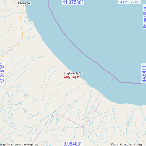
Lughaye GPS coordinates[2]
10° 41' 8.628" North, 43° 56' 38.292" East
| Map corner | latitude | longitude |
|---|---|---|
| Upper-left | 11.37586°, | 43.24085° |
| Center: | 10.68573°, | 43.94397° |
| Lower-right: | 9.99403°, | 44.6471° |
| Map W x H: | 153.6×153.6 km | = 95.4×95.4mi |
| max Lat: | 11.96611° ⇑11.3% North |
| Lughaye: | 10.68573° |
| min Lat: | ⇓88.7% South -1.21917° |
| min Long | Lughaye | max Long |
| 41.83725° | 43.94397° | 51.0773° |
| W 28.3%⇐ | ⇒71.7% E |
Elevation
Elevation of Lughaye is 9 m = 30 ft, and this is 280.9 m = 922 ft below average elevation for this country.
| Max E: |
1786 m = 5860 ft | 86.8% |
| Avg. | 289.9 m = 951 ft | |
| Lughaye | 9 m = 30 ft | |
Min E: |
-2 m = -7 ft | 13.2% |
See also: Somalia elevation on elevation.city.
Geographical zone
Lughaye is located in North Torrid zone (between Equator and Tropic of Cancer). Distance of Equator is 1188.1 km =738.3 mi to South.| Distance of | km | miles | from Lughaye |
|---|---|---|---|
| North Pole | 8818.9 | 5479.8 | to North |
| Arctic Circle | 6213 | 3860.6 | to North |
| Tropic Cancer | 1417.8 | 881 | to North |
| Equator | 1188.1 | 738.3 | to South |


Nearby cities:
8 places around Lughaye: (largest is in red/bold)
• Baki
107.3 km =66.7 mi,  214°
214°
• Baligubadle
187.5 km =116.5 mi,  178°
178°
• Berbera
120.2 km =74.7 mi,  103°
103°
• Burao
216.8 km =134.7 mi,  126°
126°
• Ceek
243.3 km =151.2 mi,  140°
140°
• Ceerigaabo
374.2 km =232.5 mi,  91°
91°
• Hargeysa
125.9 km =78.2 mi,  173°
173°
• Oodweyne
187.6 km =116.6 mi, 139°
Sources, notices
• [Note1] Compared only with cities in Somalia existing in our database
• [Src1] Map data: © OpenStreetMap contributors (CC-BY-SA)
• [Src2] Other city data from geonames.org with taken over terms of usage.
• [Src3] Geographical zone / Annual Mean Temperature by Robert A. Rohde @ Wikipedia
