Hargeysa geodata
Hargeysa (Woqooyi Galbeed) is a seat of a first-order administrative division; located in Somalia in Africa/Mogadishu (GMT+3) time zone. With population of 477,876 people, there is 1 city with bigger population in this country. Compared to other cities in Somalia, 79.2% of cities are located further ↓South; 67.9% of cities are located further →East and 94.3% of cities have lower elevation than Hargeysa. Note1


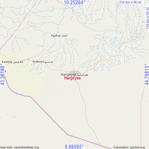
Hargeysa GPS coordinates[2]
9° 33' 36" North, 44° 3' 54" East
| Map corner | latitude | longitude |
|---|---|---|
| Upper-left | 10.25264°, | 43.36188° |
| Center: | 9.56°, | 44.065° |
| Lower-right: | 8.86595°, | 44.76813° |
| Map W x H: | 154.2×154.2 km | = 95.8×95.8mi |
| max Lat: | 11.96611° ⇑20.8% North |
| Hargeysa: | 9.56° |
| min Lat: | ⇓79.2% South -1.21917° |
| min Long | Hargeysa | max Long |
| 41.83725° | 44.065° | 51.0773° |
| W 32.1%⇐ | ⇒67.9% E |
Elevation
Elevation of Hargeysa is 1261 m = 4137 ft, and this is 971.1 m = 3186 ft above average elevation for this country.
| Max E: |
1786 m = 5860 ft | 5.7% |
| Hargeysa | 1261 m 4137 ft | |
| Avg. | 289.9 m = 951 ft | |
Min E: |
-2 m = -7 ft | 94.3% |
See also: Hargeysa elevation on elevation.city.
Geographical zone
Hargeysa is located in North Torrid zone (between Equator and Tropic of Cancer). Distance of Equator is 1063 km =660.5 mi to South.| Distance of | km | miles | from Hargeysa |
|---|---|---|---|
| North Pole | 8944.1 | 5557.6 | to North |
| Arctic Circle | 6338.2 | 3938.4 | to North |
| Tropic Cancer | 1542.9 | 958.7 | to North |
| Equator | 1063 | 660.5 | to South |


Nearby cities:
9 places around Hargeysa: (largest is in red/bold)
• Baki
83.1 km =51.6 mi,  296°
296°
• Baligubadle
62.7 km =39 mi,  186°
186°
• Berbera
142.7 km =88.7 mi,  46°
46°
• Burao
161.1 km =100.1 mi,  91°
91°
• Ceek
155 km =96.3 mi,  113°
113°
• Ceerigaabo
380.2 km =236.2 mi,  72°
72°
• Laascaanood
381.3 km =236.9 mi, 108°
• Lughaye
125.9 km =78.2 mi,  353°
353°
• Oodweyne
110.8 km =68.8 mi,  98°
98°
Sources, notices
• [Note1] Compared only with cities in Somalia existing in our database
• [Src1] Map data: © OpenStreetMap contributors (CC-BY-SA)
• [Src2] Other city data from geonames.org with taken over terms of usage.
• [Src3] Geographical zone / Annual Mean Temperature by Robert A. Rohde @ Wikipedia
