Burao geodata
Burao (Togdheer) is a seat of a first-order administrative division; located in Somalia in Africa/Mogadishu (GMT+3) time zone. With population of 99,270 people, there are 7 cities with bigger population in this country. Compared to other cities in Somalia, 77.4% of cities are located further ↓South; 56.6% of cities are located further ←West and 90.6% of cities have lower elevation than Burao. Note1


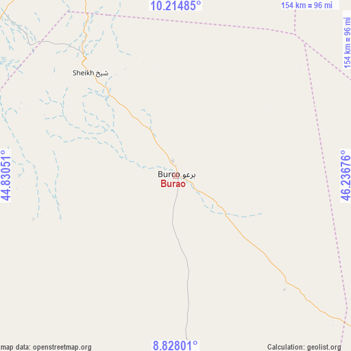
Burao GPS coordinates[2]
9° 31' 19.668" North, 45° 32' 1.068" East
| Map corner | latitude | longitude |
|---|---|---|
| Upper-left | 10.21485°, | 44.83051° |
| Center: | 9.52213°, | 45.53363° |
| Lower-right: | 8.82801°, | 46.23676° |
| Map W x H: | 154.2×154.2 km | = 95.8×95.8mi |
| max Lat: | 11.96611° ⇑22.6% North |
| Burao: | 9.52213° |
| min Lat: | ⇓77.4% South -1.21917° |
| min Long | Burao | max Long |
| 41.83725° | 45.53363° | 51.0773° |
| W 56.6%⇐ | ⇒43.4% E |
Elevation
Elevation of Burao is 1041 m = 3415 ft, and this is 751.1 m = 2464 ft above average elevation for this country.
| Max E: |
1786 m = 5860 ft | 9.4% |
| Burao | 1041 m 3415 ft | |
| Avg. | 289.9 m = 951 ft | |
Min E: |
-2 m = -7 ft | 90.6% |
See also: Burao elevation on elevation.city.
Geographical zone
Burao is located in North Torrid zone (between Equator and Tropic of Cancer). Distance of Equator is 1058.8 km =657.9 mi to South.| Distance of | km | miles | from Burao |
|---|---|---|---|
| North Pole | 8948.3 | 5560.2 | to North |
| Arctic Circle | 6342.4 | 3941 | to North |
| Tropic Cancer | 1547.2 | 961.4 | to North |
| Equator | 1058.8 | 657.9 | to South |


Nearby cities:
13 places around Burao: (largest is in red/bold)
• Adado
395.3 km =245.6 mi,  162°
162°
• Baki
239 km =148.5 mi,  279°
279°
• Baligubadle
178 km =110.6 mi,  250°
250°
• Berbera
116.8 km =72.6 mi,  330°
330°
• Ceek
61.3 km =38.1 mi,  198°
198°
• Ceerigaabo
234.8 km =145.9 mi,  58°
58°
• Gaalkacyo
370.5 km =230.2 mi,  145°
145°
• Garoowe
347 km =215.6 mi,  111°
111°
• Hargeysa
161.1 km =100.1 mi,  271°
271°
• Laascaanood
231.8 km =144 mi,  120°
120°
• Las Khorey
343.5 km =213.4 mi, 57°
• Lughaye
216.8 km =134.7 mi,  306°
306°
• Oodweyne
53 km =32.9 mi,  256°
256°
Sources, notices
• [Note1] Compared only with cities in Somalia existing in our database
• [Src1] Map data: © OpenStreetMap contributors (CC-BY-SA)
• [Src2] Other city data from geonames.org with taken over terms of usage.
• [Src3] Geographical zone / Annual Mean Temperature by Robert A. Rohde @ Wikipedia
