Caluula geodata
Caluula (Bari) is a seat of a second-order administrative division; located in Somalia in Africa/Mogadishu (GMT+3) time zone. With population of 6,100 people, there are 41 cities with bigger population in this country. Compared to other cities in Somalia, 100% of cities are located further ↓South; 94.3% of cities are located further ←West and 98.1% of cities have higher elevation than Caluula. Note1


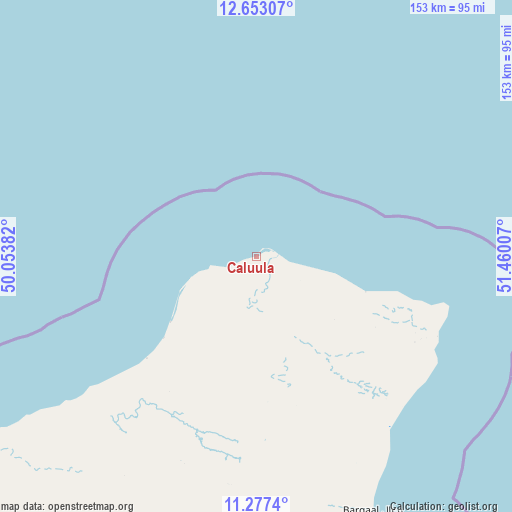
Caluula GPS coordinates[2]
11° 57' 57.996" North, 50° 45' 24.984" East
| Map corner | latitude | longitude |
|---|---|---|
| Upper-left | 12.65307°, | 50.05382° |
| Center: | 11.96611°, | 50.75694° |
| Lower-right: | 11.2774°, | 51.46007° |
| Map W x H: | 153×153 km | = 95.1×95.1mi |
| max Lat: | 11.96611° ⇑0% North |
| Caluula: | 11.96611° |
| min Lat: | ⇓100% South -1.21917° |
| min Long | Caluula | max Long |
| 41.83725° | 50.75694° | 51.0773° |
| W 94.3%⇐ | ⇒5.7% E |
Elevation
Elevation of Caluula is 4 m = 13 ft, and this is 285.9 m = 938 ft below average elevation for this country.
| Max E: |
1786 m = 5860 ft | 98.1% |
| Avg. | 289.9 m = 951 ft | |
| Caluula | 4 m = 13 ft | |
Min E: |
-2 m = -7 ft | 1.9% |
See also: Somalia elevation on elevation.city.
Geographical zone
Caluula is located in North Torrid zone (between Equator and Tropic of Cancer). Distance of this Northern Tropic circle is 1275.4 km =792.5 mi to North.| Distance of | km | miles | from Caluula |
|---|---|---|---|
| North Pole | 8676.6 | 5391.4 | to North |
| Arctic Circle | 6070.7 | 3772.2 | to North |
| Tropic Cancer | 1275.4 | 792.5 | to North |
| Equator | 1330.5 | 826.7 | to South |


Nearby cities:
8 places around Caluula: (largest is in red/bold)
• Bandarbeyla
274.9 km =170.8 mi,  178°
178°
• Bargaal
83.2 km =51.7 mi,  155°
155°
• Bereeda
34.4 km =21.4 mi,  108°
108°
• Bosaso
187.6 km =116.6 mi,  246°
246°
• Ceerigaabo
398.8 km =247.8 mi, 247°
• Iskushuban
195.7 km =121.6 mi,  197°
197°
• Las Khorey
293 km =182.1 mi, 252°
• Qandala
110.8 km =68.8 mi,  240°
240°
Sources, notices
• [Note1] Compared only with cities in Somalia existing in our database
• [Src1] Map data: © OpenStreetMap contributors (CC-BY-SA)
• [Src2] Other city data from geonames.org with taken over terms of usage.
• [Src3] Geographical zone / Annual Mean Temperature by Robert A. Rohde @ Wikipedia
