Qandala geodata
Qandala (Bari) is a populated place; located in Somalia in Africa/Mogadishu (GMT+3) time zone. With population of 15,923 people, there are 26 cities with bigger population in this country. Compared to other cities in Somalia, 96.2% of cities are located further ↓South; 90.6% of cities are located further ←West and 88.7% of cities have higher elevation than Qandala. Note1


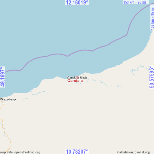
Qandala GPS coordinates[2]
11° 28' 19.092" North, 49° 52' 22.152" East
| Map corner | latitude | longitude |
|---|---|---|
| Upper-left | 12.16019°, | 49.1697° |
| Center: | 11.47197°, | 49.87282° |
| Lower-right: | 10.78207°, | 50.57595° |
| Map W x H: | 153.2×153.2 km | = 95.2×95.2mi |
| max Lat: | 11.96611° ⇑3.8% North |
| Qandala: | 11.47197° |
| min Lat: | ⇓96.2% South -1.21917° |
| min Long | Qandala | max Long |
| 41.83725° | 49.87282° | 51.0773° |
| W 90.6%⇐ | ⇒9.4% E |
Elevation
Elevation of Qandala is 8 m = 26 ft, and this is 281.9 m = 925 ft below average elevation for this country.
| Max E: |
1786 m = 5860 ft | 88.7% |
| Avg. | 289.9 m = 951 ft | |
| Qandala | 8 m = 26 ft | |
Min E: |
-2 m = -7 ft | 11.3% |
See also: Somalia elevation on elevation.city.
Geographical zone
Qandala is located in North Torrid zone (between Equator and Tropic of Cancer). Distance of Equator is 1275.6 km =792.6 mi to South.| Distance of | km | miles | from Qandala |
|---|---|---|---|
| North Pole | 8731.5 | 5425.5 | to North |
| Arctic Circle | 6125.6 | 3806.3 | to North |
| Tropic Cancer | 1330.4 | 826.7 | to North |
| Equator | 1275.6 | 792.6 | to South |


Nearby cities:
11 places around Qandala: (largest is in red/bold)
• Bandarbeyla
242.7 km =150.8 mi,  154°
154°
• Bargaal
132.9 km =82.6 mi,  98°
98°
• Bereeda
136.4 km =84.8 mi,  71°
71°
• Bosaso
78.2 km =48.6 mi,  254°
254°
• Caluula
110.8 km =68.8 mi,  60°
60°
• Ceerigaabo
289.4 km =179.8 mi, 250°
• Eyl
388.3 km =241.3 mi,  180°
180°
• Garoowe
373.7 km =232.2 mi,  204°
204°
• Iskushuban
137.8 km =85.6 mi,  163°
163°
• Laascaanood
432 km =268.4 mi,  219°
219°
• Las Khorey
186 km =115.6 mi,  259°
259°
Sources, notices
• [Note1] Compared only with cities in Somalia existing in our database
• [Src1] Map data: © OpenStreetMap contributors (CC-BY-SA)
• [Src2] Other city data from geonames.org with taken over terms of usage.
• [Src3] Geographical zone / Annual Mean Temperature by Robert A. Rohde @ Wikipedia
