Intipucá geodata
Intipucá (La Unión) is a populated place; located in El Salvador in America/El_Salvador (GMT-6) time zone. With population of 3,540 people, there are 75 cities with bigger population in this country. Compared to other cities in El Salvador, 100% of cities are located further ↑North; 90% of cities are located further ←West and 91% of cities have higher elevation than Intipucá. Note1


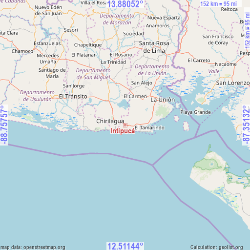
Intipucá GPS coordinates[2]
13° 11' 48.984" North, 88° 3' 15.984" West
| Map corner | latitude | longitude |
|---|---|---|
| Upper-left | 13.88052°, | -88.75757° |
| Center: | 13.19694°, | -88.05444° |
| Lower-right: | 12.51144°, | -87.35132° |
| Map W x H: | 152.2×152.2 km | = 94.6×94.6mi |
| max Lat: | 14.33333° ⇑100% North |
| Intipucá: | 13.19694° |
| min Lat: | ⇓0% South 13.19694° |
| min Long | Intipucá | max Long |
| -90.01583° | -88.05444° | -87.83861° |
| W 90%⇐ | ⇒10% E |
Elevation
Elevation of Intipucá is 108 m = 354 ft, and this is 363.9 m = 1194 ft below average elevation for this country.
| Max E: |
1255 m = 4117 ft | 91% |
| Avg. | 471.9 m = 1548 ft | |
| Intipucá | 108 m = 354 ft | |
Min E: |
13 m = 43 ft | 9% |
See also: El Salvador elevation on elevation.city.
Geographical zone
Intipucá is located in North Torrid zone (between Equator and Tropic of Cancer). Distance of this Northern Tropic circle is 1138.6 km =707.5 mi to North.| Distance of | km | miles | from Intipucá |
|---|---|---|---|
| North Pole | 8539.7 | 5306.3 | to North |
| Arctic Circle | 5933.8 | 3687.1 | to North |
| Tropic Cancer | 1138.6 | 707.5 | to North |
| Equator | 1467.4 | 911.8 | to South |


Nearby cities:
15 places around Intipucá: (largest is in red/bold)
• Chinameca
46.5 km =28.9 mi,  316°
316°
• Chirilagua
9.5 km =5.9 mi,  285°
285°
• Concepción Batres
37.8 km =23.5 mi,  296°
296°
• Conchagua
23.9 km =14.9 mi,  59°
59°
• El Tránsito
36.2 km =22.5 mi, 298°
• Jocoro
46.8 km =29.1 mi,  5°
5°
• Jucuarán
21.9 km =13.6 mi, 286°
• La Unión
27.6 km =17.1 mi, 55°
• Moncagua
43 km =26.7 mi,  330°
330°
• Pasaquina
48.9 km =30.4 mi,  28°
28°
• San Alejo
27.9 km =17.3 mi,  20°
20°
• San Miguel
34.8 km =21.6 mi,  336°
336°
• San Rafael Oriente
38.1 km =23.7 mi, 302°
• Santa Elena
44.3 km =27.5 mi, 297°
• Usulután
46.1 km =28.6 mi, 291°
Sources, notices
• [Note1] Compared only with cities in El Salvador existing in our database
• [Src1] Map data: © OpenStreetMap contributors (CC-BY-SA)
• [Src2] Other city data from geonames.org with taken over terms of usage.
• [Src3] Geographical zone / Annual Mean Temperature by Robert A. Rohde @ Wikipedia
