Chirilagua geodata
Chirilagua (San Miguel) is a populated place; located in El Salvador in America/El_Salvador (GMT-6) time zone. With population of 6,393 people, there are 59 cities with bigger population in this country. Compared to other cities in El Salvador, 99% of cities are located further ↑North; 87% of cities are located further ←West and 76% of cities have higher elevation than Chirilagua. Note1


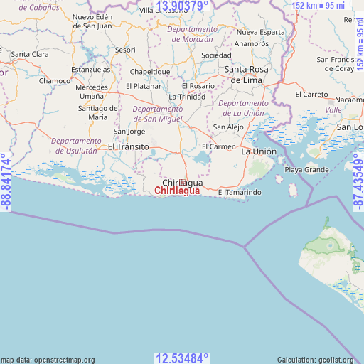
Chirilagua GPS coordinates[2]
13° 13' 13.008" North, 88° 8' 18.996" West
| Map corner | latitude | longitude |
|---|---|---|
| Upper-left | 13.90379°, | -88.84174° |
| Center: | 13.22028°, | -88.13861° |
| Lower-right: | 12.53484°, | -87.43549° |
| Map W x H: | 152.2×152.2 km | = 94.6×94.6mi |
| max Lat: | 14.33333° ⇑99% North |
| Chirilagua: | 13.22028° |
| min Lat: | ⇓1% South 13.19694° |
| min Long | Chirilagua | max Long |
| -90.01583° | -88.13861° | -87.83861° |
| W 87%⇐ | ⇒13% E |
Elevation
Elevation of Chirilagua is 228 m = 748 ft, and this is 243.9 m = 800 ft below average elevation for this country.
| Max E: |
1255 m = 4117 ft | 76% |
| Avg. | 471.9 m = 1548 ft | |
| Chirilagua | 228 m = 748 ft | |
Min E: |
13 m = 43 ft | 24% |
See also: El Salvador elevation on elevation.city.
Geographical zone
Chirilagua is located in North Torrid zone (between Equator and Tropic of Cancer). Distance of this Northern Tropic circle is 1136 km =705.9 mi to North.| Distance of | km | miles | from Chirilagua |
|---|---|---|---|
| North Pole | 8537.1 | 5304.7 | to North |
| Arctic Circle | 5931.2 | 3685.5 | to North |
| Tropic Cancer | 1136 | 705.9 | to North |
| Equator | 1470 | 913.4 | to South |


Nearby cities:
15 places around Chirilagua: (largest is in red/bold)
• Chinameca
38.6 km =24 mi,  323°
323°
• Concepción Batres
28.6 km =17.8 mi,  300°
300°
• Conchagua
31.2 km =19.4 mi,  71°
71°
• El Tránsito
27 km =16.8 mi, 302°
• Intipucá
9.5 km =5.9 mi,  105°
105°
• Jucuapa
42.3 km =26.3 mi, 321°
• Jucuarán
12.4 km =7.7 mi,  287°
287°
• La Unión
34.4 km =21.4 mi, 67°
• Moncagua
36.8 km =22.9 mi,  340°
340°
• Nueva Guadalupe
41.6 km =25.8 mi,  326°
326°
• San Alejo
30.2 km =18.8 mi,  38°
38°
• San Miguel
29.6 km =18.4 mi,  350°
350°
• San Rafael Oriente
29.2 km =18.1 mi,  308°
308°
• Santa Elena
35.1 km =21.8 mi, 301°
• Usulután
36.7 km =22.8 mi, 293°
Sources, notices
• [Note1] Compared only with cities in El Salvador existing in our database
• [Src1] Map data: © OpenStreetMap contributors (CC-BY-SA)
• [Src2] Other city data from geonames.org with taken over terms of usage.
• [Src3] Geographical zone / Annual Mean Temperature by Robert A. Rohde @ Wikipedia
