La Unión geodata
La Unión is a seat of a first-order administrative division; located in El Salvador in America/El_Salvador (GMT-6) time zone. With population of 26,807 people, there are 21 cities with bigger population in this country. Compared to other cities in El Salvador, 94% of cities are located further ↑North; 98% of cities are located further ←West and 98% of cities have higher elevation than La Unión. Note1


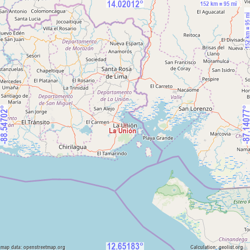
La Unión GPS coordinates[2]
13° 20' 12.984" North, 87° 50' 38.004" West
| Map corner | latitude | longitude |
|---|---|---|
| Upper-left | 14.02012°, | -88.54702° |
| Center: | 13.33694°, | -87.84389° |
| Lower-right: | 12.65183°, | -87.14077° |
| Map W x H: | 152.1×152.1 km | = 94.5×94.5mi |
| max Lat: | 14.33333° ⇑94% North |
| La Unión: | 13.33694° |
| min Lat: | ⇓6% South 13.19694° |
| min Long | La Unión | max Long |
| -90.01583° | -87.84389° | -87.83861° |
| W 98%⇐ | ⇒2% E |
Elevation
Elevation of La Unión is 16 m = 52 ft, and this is 455.9 m = 1496 ft below average elevation for this country.
| Max E: |
1255 m = 4117 ft | 98% |
| Avg. | 471.9 m = 1548 ft | |
| La Unión | 16 m = 52 ft | |
Min E: |
13 m = 43 ft | 2% |
See also: El Salvador elevation on elevation.city.
Geographical zone
La Unión is located in North Torrid zone (between Equator and Tropic of Cancer). Distance of this Northern Tropic circle is 1123 km =697.8 mi to North.| Distance of | km | miles | from La Unión |
|---|---|---|---|
| North Pole | 8524.1 | 5296.6 | to North |
| Arctic Circle | 5918.2 | 3677.4 | to North |
| Tropic Cancer | 1123 | 697.8 | to North |
| Equator | 1482.9 | 921.4 | to South |


Nearby cities:
15 places around La Unión: (largest is in red/bold)
• Anamorós
45 km =28 mi,  355°
355°
• Chirilagua
34.4 km =21.4 mi,  247°
247°
• Conchagua
3.9 km =2.4 mi,  214°
214°
• Guatajiagua
53.2 km =33.1 mi,  313°
313°
• Intipucá
27.6 km =17.1 mi,  235°
235°
• Jocoro
36.3 km =22.6 mi,  329°
329°
• Jucuarán
44.7 km =27.8 mi,  258°
258°
• Moncagua
49 km =30.4 mi,  296°
296°
• Nueva Esparta
49.7 km =30.9 mi,  0°
0°
• Pasaquina
27.5 km =17.1 mi, 0°
• San Alejo
16.6 km =10.3 mi, 309°
• San Francisco
49 km =30.4 mi, 325°
• San Miguel
40.2 km =25 mi,  293°
293°
• Santa Rosa de Lima
32.4 km =20.1 mi,  350°
350°
• Sociedad
44.5 km =27.7 mi,  335°
335°
Sources, notices
• [Note1] Compared only with cities in El Salvador existing in our database
• [Src1] Map data: © OpenStreetMap contributors (CC-BY-SA)
• [Src2] Other city data from geonames.org with taken over terms of usage.
• [Src3] Geographical zone / Annual Mean Temperature by Robert A. Rohde @ Wikipedia
