El Rosario geodata
El Rosario (La Paz) is a populated place; located in El Salvador in America/El_Salvador (GMT-6) time zone. With population of 5,620 people, there are 68 cities with bigger population in this country. Compared to other cities in El Salvador, 82% of cities are located further ↑North; 51% of cities are located further ←West and 93% of cities have higher elevation than El Rosario. Note1


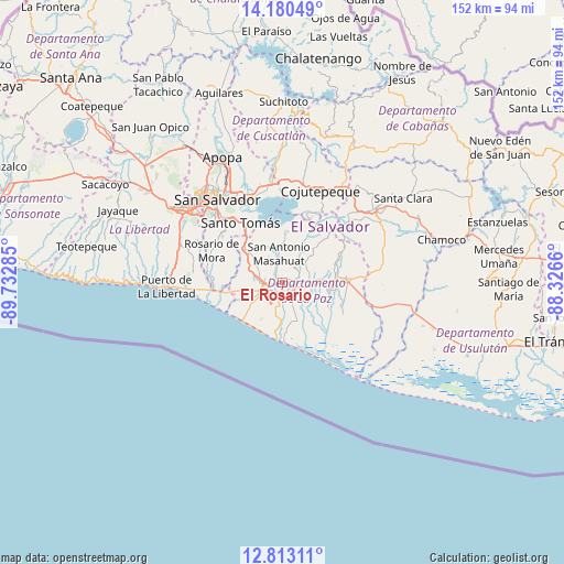
El Rosario GPS coordinates[2]
13° 29' 52.008" North, 89° 1' 46.992" West
| Map corner | latitude | longitude |
|---|---|---|
| Upper-left | 14.18049°, | -89.73285° |
| Center: | 13.49778°, | -89.02972° |
| Lower-right: | 12.81311°, | -88.3266° |
| Map W x H: | 152×152 km | = 94.4×94.4mi |
| max Lat: | 14.33333° ⇑82% North |
| El Rosario: | 13.49778° |
| min Lat: | ⇓18% South 13.19694° |
| min Long | El Rosario | max Long |
| -90.01583° | -89.02972° | -87.83861° |
| W 51%⇐ | ⇒49% E |
Elevation
Elevation of El Rosario is 104 m = 341 ft, and this is 367.9 m = 1207 ft below average elevation for this country.
| Max E: |
1255 m = 4117 ft | 93% |
| Avg. | 471.9 m = 1548 ft | |
| El Rosario | 104 m = 341 ft | |
Min E: |
13 m = 43 ft | 7% |
See also: El Salvador elevation on elevation.city.
Geographical zone
El Rosario is located in North Torrid zone (between Equator and Tropic of Cancer). Distance of this Northern Tropic circle is 1105.1 km =686.7 mi to North.| Distance of | km | miles | from El Rosario |
|---|---|---|---|
| North Pole | 8506.2 | 5285.5 | to North |
| Arctic Circle | 5900.4 | 3666.3 | to North |
| Tropic Cancer | 1105.1 | 686.7 | to North |
| Equator | 1500.8 | 932.6 | to South |


Nearby cities:
15 places around El Rosario: (largest is in red/bold)
• Cojutepeque
26.5 km =16.5 mi,  23°
23°
• Delgado
29.4 km =18.3 mi,  328°
328°
• Ilopango
24.3 km =15.1 mi,  339°
339°
• Olocuilta
12.4 km =7.7 mi,  310°
310°
• Panchimalco
20.7 km =12.9 mi, 308°
• Rosario de Mora
21.2 km =13.2 mi,  293°
293°
• San Marcos
24.4 km =15.2 mi,  317°
317°
• San Pedro Masahuat
5.2 km =3.2 mi,  349°
349°
• San Salvador
27.3 km =17 mi, 321°
• San Vicente
29 km =18 mi,  58°
58°
• Santiago Nonualco
8.9 km =5.5 mi,  76°
76°
• Santo Tomás
19.5 km =12.1 mi, 324°
• Soyapango
26.5 km =16.5 mi, 333°
• Zacatecoluca
17.6 km =10.9 mi,  89°
89°
• Zaragoza
29.8 km =18.5 mi, 289°
Sources, notices
• [Note1] Compared only with cities in El Salvador existing in our database
• [Src1] Map data: © OpenStreetMap contributors (CC-BY-SA)
• [Src2] Other city data from geonames.org with taken over terms of usage.
• [Src3] Geographical zone / Annual Mean Temperature by Robert A. Rohde @ Wikipedia
