Cojutepeque geodata
Cojutepeque (Cuscatlán) is a seat of a first-order administrative division; located in El Salvador in America/El_Salvador (GMT-6) time zone. With population of 48,411 people, there are 11 cities with bigger population in this country. Compared to other cities in El Salvador, 51% of cities are located further ↓South; 56% of cities are located further ←West and 92% of cities have lower elevation than Cojutepeque. Note1


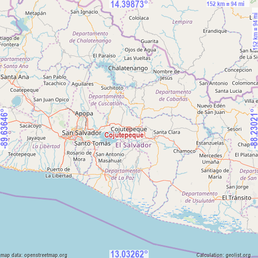
Cojutepeque GPS coordinates[2]
13° 43' 0.012" North, 88° 55' 59.988" West
| Map corner | latitude | longitude |
|---|---|---|
| Upper-left | 14.39873°, | -89.63646° |
| Center: | 13.71667°, | -88.93333° |
| Lower-right: | 13.03262°, | -88.23021° |
| Map W x H: | 151.9×151.9 km | = 94.4×94.4mi |
| max Lat: | 14.33333° ⇑49% North |
| Cojutepeque: | 13.71667° |
| min Lat: | ⇓51% South 13.19694° |
| min Long | Cojutepeque | max Long |
| -90.01583° | -88.93333° | -87.83861° |
| W 56%⇐ | ⇒44% E |
Elevation
Elevation of Cojutepeque is 874 m = 2867 ft, and this is 402.1 m = 1319 ft above average elevation for this country.
| Max E: |
1255 m = 4117 ft | 8% |
| Cojutepeque | 874 m 2867 ft | |
| Avg. | 471.9 m = 1548 ft | |
Min E: |
13 m = 43 ft | 92% |
See also: Cojutepeque elevation on elevation.city.
Geographical zone
Cojutepeque is located in North Torrid zone (between Equator and Tropic of Cancer). Distance of this Northern Tropic circle is 1080.8 km =671.6 mi to North.| Distance of | km | miles | from Cojutepeque |
|---|---|---|---|
| North Pole | 8481.9 | 5270.4 | to North |
| Arctic Circle | 5876 | 3651.2 | to North |
| Tropic Cancer | 1080.8 | 671.6 | to North |
| Equator | 1525.2 | 947.7 | to South |


Nearby cities:
15 places around Cojutepeque: (largest is in red/bold)
• Apastepeque
17.1 km =10.6 mi,  108°
108°
• Delgado
25.6 km =15.9 mi,  271°
271°
• Ilopango
19.1 km =11.9 mi,  264°
264°
• Olocuilta
25.7 km =16 mi,  230°
230°
• San Martín
7.6 km =4.7 mi,  13°
13°
• San Pedro Masahuat
22.4 km =13.9 mi,  210°
210°
• San Sebastián
11 km =6.8 mi,  80°
80°
• San Vicente
17.1 km =10.6 mi,  122°
122°
• Santiago Nonualco
22.3 km =13.9 mi,  184°
184°
• Santo Tomás
23.2 km =14.4 mi,  248°
248°
• Soyapango
22.3 km =13.9 mi, 268°
• Tecoluca
11.2 km =7 mi,  316°
316°
• Tenancingo
14.1 km =8.8 mi,  337°
337°
• Tonacatepeque
21.3 km =13.2 mi,  289°
289°
• Zacatecoluca
25.1 km =15.6 mi,  163°
163°
Sources, notices
• [Note1] Compared only with cities in El Salvador existing in our database
• [Src1] Map data: © OpenStreetMap contributors (CC-BY-SA)
• [Src2] Other city data from geonames.org with taken over terms of usage.
• [Src3] Geographical zone / Annual Mean Temperature by Robert A. Rohde @ Wikipedia
