Sociedad geodata
Sociedad (Morazán) is a populated place; located in El Salvador in America/El_Salvador (GMT-6) time zone. With population of 1,770 people, there are 93 cities with bigger population in this country. Compared to other cities in El Salvador, 54% of cities are located further ↑North; 91% of cities are located further ←West and 62% of cities have higher elevation than Sociedad. Note1


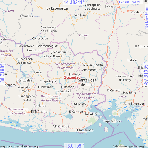
Sociedad GPS coordinates[2]
13° 42' 0" North, 88° 1' 0.012" West
| Map corner | latitude | longitude |
|---|---|---|
| Upper-left | 14.38211°, | -88.7198° |
| Center: | 13.7°, | -88.01667° |
| Lower-right: | 13.0159°, | -87.31355° |
| Map W x H: | 151.9×151.9 km | = 94.4×94.4mi |
| max Lat: | 14.33333° ⇑54% North |
| Sociedad: | 13.7° |
| min Lat: | ⇓46% South 13.19694° |
| min Long | Sociedad | max Long |
| -90.01583° | -88.01667° | -87.83861° |
| W 91%⇐ | ⇒9% E |
Elevation
Elevation of Sociedad is 346 m = 1135 ft, and this is 125.9 m = 413 ft below average elevation for this country.
| Max E: |
1255 m = 4117 ft | 62% |
| Avg. | 471.9 m = 1548 ft | |
| Sociedad | 346 m = 1135 ft | |
Min E: |
13 m = 43 ft | 38% |
See also: El Salvador elevation on elevation.city.
Geographical zone
Sociedad is located in North Torrid zone (between Equator and Tropic of Cancer). Distance of this Northern Tropic circle is 1082.6 km =672.7 mi to North.| Distance of | km | miles | from Sociedad |
|---|---|---|---|
| North Pole | 8483.8 | 5271.6 | to North |
| Arctic Circle | 5877.9 | 3652.4 | to North |
| Tropic Cancer | 1082.6 | 672.7 | to North |
| Equator | 1523.3 | 946.5 | to South |


Nearby cities:
15 places around Sociedad: (largest is in red/bold)
• Anamorós
16.1 km =10 mi,  73°
73°
• Cacaopera
10.3 km =6.4 mi,  315°
315°
• Chapeltique
28 km =17.4 mi,  254°
254°
• Ciudad Barrios
28 km =17.4 mi,  285°
285°
• Corinto
13.3 km =8.3 mi,  21°
21°
• Guatajiagua
20.1 km =12.5 mi,  259°
259°
• Jocoro
9.3 km =5.8 mi,  180°
180°
• Moncagua
31.3 km =19.4 mi,  233°
233°
• Nueva Esparta
21.4 km =13.3 mi,  64°
64°
• Pasaquina
22.9 km =14.2 mi,  124°
124°
• San Alejo
30.4 km =18.9 mi,  169°
169°
• San Francisco
9 km =5.6 mi,  270°
270°
• San Miguel
30.1 km =18.7 mi,  216°
216°
• Santa Rosa de Lima
15.7 km =9.8 mi, 122°
• Sesori
37.9 km =23.5 mi, 272°
Sources, notices
• [Note1] Compared only with cities in El Salvador existing in our database
• [Src1] Map data: © OpenStreetMap contributors (CC-BY-SA)
• [Src2] Other city data from geonames.org with taken over terms of usage.
• [Src3] Geographical zone / Annual Mean Temperature by Robert A. Rohde @ Wikipedia
