Tecoluca geodata
Tecoluca (Cuscatlán) is a populated place; located in El Salvador in America/El_Salvador (GMT-6) time zone. With population of 2,781 people, there are 81 cities with bigger population in this country. Compared to other cities in El Salvador, 71% of cities are located further ↓South; 53% of cities are located further ←West and 87% of cities have lower elevation than Tecoluca. Note1


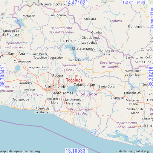
Tecoluca GPS coordinates[2]
13° 47' 21.012" North, 89° 0' 19.008" West
| Map corner | latitude | longitude |
|---|---|---|
| Upper-left | 14.47102°, | -89.70841° |
| Center: | 13.78917°, | -89.00528° |
| Lower-right: | 13.10533°, | -88.30216° |
| Map W x H: | 151.9×151.9 km | = 94.4×94.4mi |
| max Lat: | 14.33333° ⇑29% North |
| Tecoluca: | 13.78917° |
| min Lat: | ⇓71% South 13.19694° |
| min Long | Tecoluca | max Long |
| -90.01583° | -89.00528° | -87.83861° |
| W 53%⇐ | ⇒47% E |
Elevation
Elevation of Tecoluca is 758 m = 2487 ft, and this is 286.1 m = 939 ft above average elevation for this country.
| Max E: |
1255 m = 4117 ft | 13% |
| Tecoluca | 758 m 2487 ft | |
| Avg. | 471.9 m = 1548 ft | |
Min E: |
13 m = 43 ft | 87% |
See also: El Salvador elevation on elevation.city.
Geographical zone
Tecoluca is located in North Torrid zone (between Equator and Tropic of Cancer). Distance of this Northern Tropic circle is 1072.7 km =666.5 mi to North.| Distance of | km | miles | from Tecoluca |
|---|---|---|---|
| North Pole | 8473.8 | 5265.4 | to North |
| Arctic Circle | 5868 | 3646.2 | to North |
| Tropic Cancer | 1072.7 | 666.5 | to North |
| Equator | 1533.2 | 952.7 | to South |


Nearby cities:
15 places around Tecoluca: (largest is in red/bold)
• Apopa
18.9 km =11.7 mi,  276°
276°
• Ayutuxtepeque
22.3 km =13.9 mi,  257°
257°
• Cojutepeque
11.2 km =7 mi,  136°
136°
• Cuscatancingo
19.9 km =12.4 mi,  252°
252°
• Delgado
19.2 km =11.9 mi, 247°
• Guazapa
20.6 km =12.8 mi,  298°
298°
• Ilopango
14.9 km =9.3 mi,  229°
229°
• San Martín
9.6 km =6 mi,  93°
93°
• San Salvador
22.6 km =14 mi,  240°
240°
• San Sebastián
19.6 km =12.2 mi,  108°
108°
• Santo Tomás
21.5 km =13.4 mi,  219°
219°
• Soyapango
17 km =10.6 mi, 238°
• Suchitoto
16.7 km =10.4 mi,  351°
351°
• Tenancingo
5.5 km =3.4 mi,  25°
25°
• Tonacatepeque
12.3 km =7.6 mi,  265°
265°
Sources, notices
• [Note1] Compared only with cities in El Salvador existing in our database
• [Src1] Map data: © OpenStreetMap contributors (CC-BY-SA)
• [Src2] Other city data from geonames.org with taken over terms of usage.
• [Src3] Geographical zone / Annual Mean Temperature by Robert A. Rohde @ Wikipedia
