Tallkalakh geodata
Tallkalakh (Homs) is a seat of a second-order administrative division; located in Syria in Asia/Damascus (GMT+3) time zone. With population of 29,754 people, there are 50 cities with bigger population in this country. Compared to other cities in Syria, 69.6% of cities are located further ↑North; 71% of cities are located further →East and 79.5% of cities have higher elevation than Tallkalakh. Note1


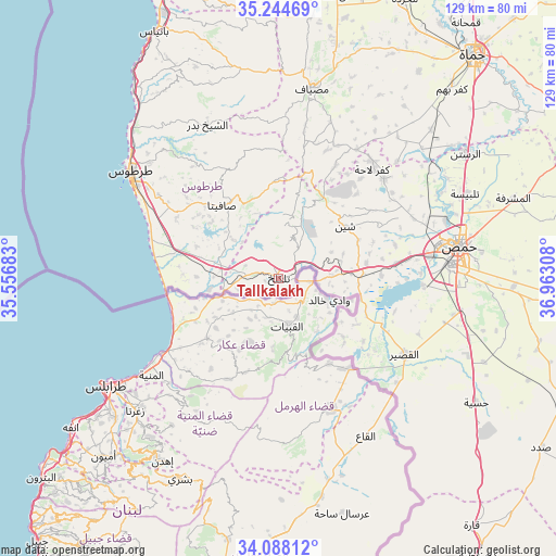
Tallkalakh GPS coordinates[2]
34° 40' 6.312" North, 36° 15' 35.82" East
| Map corner | latitude | longitude |
|---|---|---|
| Upper-left | 35.24469°, | 35.55683° |
| Center: | 34.66842°, | 36.25995° |
| Lower-right: | 34.08812°, | 36.96308° |
| Map W x H: | 128.6×128.6 km | = 79.9×79.9mi |
| max Lat: | 37.17701° ⇑69.6% North |
| Tallkalakh: | 34.66842° |
| min Lat: | ⇓30.4% South 32.39332° |
| min Long | Tallkalakh | max Long |
| 35.75572° | 36.25995° | 42.14006° |
| W 29%⇐ | ⇒71% E |
Elevation
Elevation of Tallkalakh is 288 m = 945 ft, and this is 241.1 m = 791 ft below average elevation for this country.
| Max E: |
1640 m = 5381 ft | 79.5% |
| Avg. | 529.1 m = 1736 ft | |
| Tallkalakh | 288 m = 945 ft | |
Min E: |
4 m = 13 ft | 20.5% |
See also: Syria elevation on elevation.city.
Geographical zone
Tallkalakh is located in North temperate zone (between Tropic of Cancer and the Arctic Circle). Distance of this Northern Tropic circle is 1248.8 km =776 mi to South.| Distance of | km | miles | from Tallkalakh |
|---|---|---|---|
| North Pole | 6152.3 | 3822.9 | to North |
| Arctic Circle | 3546.4 | 2203.6 | to North |
| Tropic Cancer | 1248.8 | 776 | to South |
| Equator | 3854.8 | 2395.3 | to South |


Nearby cities:
15 places around Tallkalakh: (largest is in red/bold)
• Ad Duraykīsh
27.4 km =17 mi,  337°
337°
• Al Bāriqīyah
18.1 km =11.2 mi,  350°
350°
• Al Karīmah
16.9 km =10.5 mi,  270°
270°
• Al Qabw
26.4 km =16.4 mi,  42°
42°
• Al Ḩawāsh
11.6 km =7.2 mi,  28°
28°
• An Nāşirah
13.5 km =8.4 mi,  10°
10°
• As Sīsnīyah
16.5 km =10.3 mi,  319°
319°
• Aş Şafşāfah
20.3 km =12.6 mi,  291°
291°
• Khirbat Tīn Nūr
27.4 km =17 mi,  82°
82°
• Mashtá al Ḩulw
22.9 km =14.2 mi,  357°
357°
• Ra’s al Khashūfah
25.9 km =16.1 mi,  312°
312°
• Sabbah
26.2 km =16.3 mi, 355°
• Satita
21.4 km =13.3 mi, 322°
• Shīn
19.3 km =12 mi,  50°
50°
• Ḩadīdah
12.6 km =7.8 mi,  87°
87°
Sources, notices
• [Note1] Compared only with cities in Syria existing in our database
• [Src1] Map data: © OpenStreetMap contributors (CC-BY-SA)
• [Src2] Other city data from geonames.org with taken over terms of usage.
• [Src3] Geographical zone / Annual Mean Temperature by Robert A. Rohde @ Wikipedia
