Mashtá al Ḩulw geodata
Mashtá al Ḩulw (Tartus) is a seat of a third-order administrative division; located in Syria in Asia/Damascus (GMT+3) time zone. In our database, there are 87 cities with bigger population. Compared to other cities in Syria, 61.1% of cities are located further ↑North; 71.7% of cities are located further →East and 55.8% of cities have lower elevation than Mashtá al Ḩulw. Note1


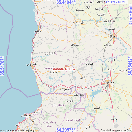
Mashtá al Ḩulw GPS coordinates[2]
34° 52' 28.632" North, 36° 15' 3.564" East
| Map corner | latitude | longitude |
|---|---|---|
| Upper-left | 35.44944°, | 35.54787° |
| Center: | 34.87462°, | 36.25099° |
| Lower-right: | 34.29575°, | 36.95412° |
| Map W x H: | 128.3×128.3 km | = 79.7×79.7mi |
| max Lat: | 37.17701° ⇑61.1% North |
| Mashtá al Ḩulw: | 34.87462° |
| min Lat: | ⇓38.9% South 32.39332° |
| min Long | Mashtá al Ḩu | max Long |
| 35.75572° | 36.25099° | 42.14006° |
| W 28.3%⇐ | ⇒71.7% E |
Elevation
Elevation of Mashtá al Ḩulw is 502 m = 1647 ft, and this is 27.1 m = 89 ft below average elevation for this country.
| Max E: |
1640 m = 5381 ft | 44.2% |
| Avg. | 529.1 m = 1736 ft | |
| Mashtá al Ḩulw | 502 m = 1647 ft | |
Min E: |
4 m = 13 ft | 55.8% |
See also: Syria elevation on elevation.city.
Geographical zone
Mashtá al Ḩulw is located in North temperate zone (between Tropic of Cancer and the Arctic Circle). Distance of this Northern Tropic circle is 1271.8 km =790.3 mi to South.| Distance of | km | miles | from Mashtá al Ḩulw |
|---|---|---|---|
| North Pole | 6129.4 | 3808.6 | to North |
| Arctic Circle | 3523.5 | 2189.4 | to North |
| Tropic Cancer | 1271.8 | 790.3 | to South |
| Equator | 3877.7 | 2409.5 | to South |


Nearby cities:
15 places around Mashtá al Ḩulw: (largest is in red/bold)
• Ad Duraykīsh
10.1 km =6.3 mi,  283°
283°
• Al Bāriqīyah
5.4 km =3.4 mi,  202°
202°
• Al Qabw
18.9 km =11.7 mi,  100°
100°
• Al Ḩawāsh
14.3 km =8.9 mi,  153°
153°
• An Nāşirah
10.2 km =6.3 mi,  161°
161°
• As Sīsnīyah
14.3 km =8.9 mi,  223°
223°
• Brummānat al Mashāyikh
17.6 km =10.9 mi,  335°
335°
• Duwayr Raslān
10.4 km =6.5 mi,  322°
322°
• Junaynat Raslān
13 km =8.1 mi,  297°
297°
• Sabbah
3.4 km =2.1 mi, 338°
• Satita
13.5 km =8.4 mi,  243°
243°
• Shīn
19 km =11.8 mi,  124°
124°
• Wādī al ‘Uyūn
15.2 km =9.4 mi, 337°
• ‘Awaj
14.5 km =9 mi,  75°
75°
• ‘Ayn Ḩalāqīm
9.7 km =6 mi,  41°
41°
Sources, notices
• [Note1] Compared only with cities in Syria existing in our database
• [Src1] Map data: © OpenStreetMap contributors (CC-BY-SA)
• [Src2] Other city data from geonames.org with taken over terms of usage.
• [Src3] Geographical zone / Annual Mean Temperature by Robert A. Rohde @ Wikipedia
