Al Ḩawāsh geodata
Al Ḩawāsh (Homs) is a seat of a third-order administrative division; located in Syria in Asia/Damascus (GMT+3) time zone. In our database, there are 87 cities with bigger population. Compared to other cities in Syria, 66.8% of cities are located further ↑North; 67.8% of cities are located further →East and 75.3% of cities have higher elevation than Al Ḩawāsh. Note1


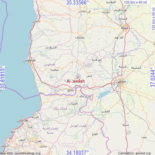
Al Ḩawāsh GPS coordinates[2]
34° 45' 36.144" North, 36° 19' 16.572" East
| Map corner | latitude | longitude |
|---|---|---|
| Upper-left | 35.33566°, | 35.61815° |
| Center: | 34.76004°, | 36.32127° |
| Lower-right: | 34.18037°, | 37.0244° |
| Map W x H: | 128.5×128.5 km | = 79.8×79.8mi |
| max Lat: | 37.17701° ⇑66.8% North |
| Al Ḩawāsh: | 34.76004° |
| min Lat: | ⇓33.2% South 32.39332° |
| min Long | Al Ḩawāsh | max Long |
| 35.75572° | 36.32127° | 42.14006° |
| W 32.2%⇐ | ⇒67.8% E |
Elevation
Elevation of Al Ḩawāsh is 333 m = 1093 ft, and this is 196.1 m = 643 ft below average elevation for this country.
| Max E: |
1640 m = 5381 ft | 75.3% |
| Avg. | 529.1 m = 1736 ft | |
| Al Ḩawāsh | 333 m = 1093 ft | |
Min E: |
4 m = 13 ft | 24.7% |
See also: Syria elevation on elevation.city.
Geographical zone
Al Ḩawāsh is located in North temperate zone (between Tropic of Cancer and the Arctic Circle). Distance of this Northern Tropic circle is 1259 km =782.3 mi to South.| Distance of | km | miles | from Al Ḩawāsh |
|---|---|---|---|
| North Pole | 6142.1 | 3816.5 | to North |
| Arctic Circle | 3536.2 | 2197.3 | to North |
| Tropic Cancer | 1259 | 782.3 | to South |
| Equator | 3865 | 2401.6 | to South |


Nearby cities:
15 places around Al Ḩawāsh: (largest is in red/bold)
• Ad Duraykīsh
22.1 km =13.7 mi,  312°
312°
• Al Bāriqīyah
11.4 km =7.1 mi, 312°
• Al Qabw
15.3 km =9.5 mi,  52°
52°
• An Nāşirah
4.5 km =2.8 mi, 313°
• As Sīsnīyah
16.5 km =10.3 mi,  278°
278°
• Kafr Lāhā
21.9 km =13.6 mi, 46°
• Khirbat Tīn Nūr
22.5 km =14 mi,  106°
106°
• Mashtá al Ḩulw
14.3 km =8.9 mi,  333°
333°
• Sabbah
17.6 km =10.9 mi, 334°
• Satita
19.8 km =12.3 mi,  290°
290°
• Shīn
9.6 km =6 mi,  77°
77°
• Tallkalakh
11.6 km =7.2 mi,  208°
208°
• Ḩadīdah
11.9 km =7.4 mi,  144°
144°
• ‘Awaj
18 km =11.2 mi,  24°
24°
• ‘Ayn Ḩalāqīm
20 km =12.4 mi,  0°
0°
Sources, notices
• [Note1] Compared only with cities in Syria existing in our database
• [Src1] Map data: © OpenStreetMap contributors (CC-BY-SA)
• [Src2] Other city data from geonames.org with taken over terms of usage.
• [Src3] Geographical zone / Annual Mean Temperature by Robert A. Rohde @ Wikipedia
