Souran geodata
Souran (Hama) is a seat of a third-order administrative division; located in Syria in Asia/Damascus (GMT+3) time zone. With population of 30,716 people, there are 47 cities with bigger population in this country. Compared to other cities in Syria, 55.1% of cities are located further ↓South; 62.9% of cities are located further ←West and 69.3% of cities have higher elevation than Souran. Note1


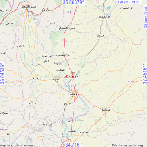
Souran GPS coordinates[2]
35° 17' 30.948" North, 36° 44' 54.528" East
| Map corner | latitude | longitude |
|---|---|---|
| Upper-left | 35.86379°, | 36.04536° |
| Center: | 35.29193°, | 36.74848° |
| Lower-right: | 34.716°, | 37.45161° |
| Map W x H: | 127.6×127.6 km | = 79.3×79.3mi |
| max Lat: | 37.17701° ⇑44.9% North |
| Souran: | 35.29193° |
| min Lat: | ⇓55.1% South 32.39332° |
| min Long | Souran | max Long |
| 35.75572° | 36.74848° | 42.14006° |
| W 62.9%⇐ | ⇒37.1% E |
Elevation
Elevation of Souran is 356 m = 1168 ft, and this is 173.1 m = 568 ft below average elevation for this country.
| Max E: |
1640 m = 5381 ft | 69.3% |
| Avg. | 529.1 m = 1736 ft | |
| Souran | 356 m = 1168 ft | |
Min E: |
4 m = 13 ft | 30.7% |
See also: Syria elevation on elevation.city.
Geographical zone
Souran is located in North temperate zone (between Tropic of Cancer and the Arctic Circle). Distance of this Northern Tropic circle is 1318.2 km =819.1 mi to South.| Distance of | km | miles | from Souran |
|---|---|---|---|
| North Pole | 6083 | 3779.8 | to North |
| Arctic Circle | 3477.1 | 2160.6 | to North |
| Tropic Cancer | 1318.2 | 819.1 | to South |
| Equator | 3924.1 | 2438.3 | to South |


Nearby cities:
15 places around Souran: (largest is in red/bold)
• Al Ḩamrā’
30.8 km =19.1 mi,  85°
85°
• As Suqaylibīyah
33.3 km =20.7 mi,  284°
284°
• At Tamāni‘ah
18.5 km =11.5 mi,  359°
359°
• Jubb Ramlah
30.3 km =18.8 mi,  252°
252°
• Kafr Zaytā
16 km =9.9 mi,  304°
304°
• Khān Shaykhūn
18.9 km =11.7 mi,  332°
332°
• Kurnāz
26 km =16.2 mi,  294°
294°
• Muḩradah
16.7 km =10.4 mi, 252°
• Mūrak
10.8 km =6.7 mi, 330°
• Tall Salḩab
33.2 km =20.6 mi,  263°
263°
• Tremseh
22.3 km =13.9 mi, 264°
• Ţayyibat al Imām
4.4 km =2.7 mi,  228°
228°
• Ḩalfāyā
13.4 km =8.3 mi, 254°
• Ḩamāh
17.8 km =11.1 mi,  177°
177°
• Ḩīsh
30 km =18.6 mi,  341°
341°
Sources, notices
• [Note1] Compared only with cities in Syria existing in our database
• [Src1] Map data: © OpenStreetMap contributors (CC-BY-SA)
• [Src2] Other city data from geonames.org with taken over terms of usage.
• [Src3] Geographical zone / Annual Mean Temperature by Robert A. Rohde @ Wikipedia
