Khān Shaykhūn geodata
Khān Shaykhūn (Idlib) is a seat of a third-order administrative division; located in Syria in Asia/Damascus (GMT+3) time zone. With population of 48,975 people, there are 28 cities with bigger population in this country. Compared to other cities in Syria, 60.4% of cities are located further ↓South; 54.4% of cities are located further ←West and 65.4% of cities have higher elevation than Khān Shaykhūn. Note1


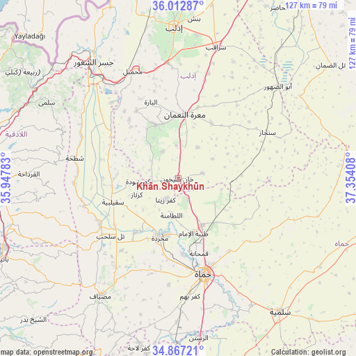
Khān Shaykhūn GPS coordinates[2]
35° 26' 31.488" North, 36° 39' 3.42" East
| Map corner | latitude | longitude |
|---|---|---|
| Upper-left | 36.01287°, | 35.94783° |
| Center: | 35.44208°, | 36.65095° |
| Lower-right: | 34.86721°, | 37.35408° |
| Map W x H: | 127.4×127.4 km | = 79.2×79.2mi |
| max Lat: | 37.17701° ⇑39.6% North |
| Khān Shaykhūn: | 35.44208° |
| min Lat: | ⇓60.4% South 32.39332° |
| min Long | Khān Shaykhūn | max Long |
| 35.75572° | 36.65095° | 42.14006° |
| W 54.4%⇐ | ⇒45.6% E |
Elevation
Elevation of Khān Shaykhūn is 376 m = 1234 ft, and this is 153.1 m = 502 ft below average elevation for this country.
| Max E: |
1640 m = 5381 ft | 65.4% |
| Avg. | 529.1 m = 1736 ft | |
| Khān Shaykhūn | 376 m = 1234 ft | |
Min E: |
4 m = 13 ft | 34.6% |
See also: Khān Shaykhūn elevation on elevation.city.
Geographical zone
Khān Shaykhūn is located in North temperate zone (between Tropic of Cancer and the Arctic Circle). Distance of this Northern Tropic circle is 1334.9 km =829.5 mi to South.| Distance of | km | miles | from Khān Shaykhūn |
|---|---|---|---|
| North Pole | 6066.3 | 3769.4 | to North |
| Arctic Circle | 3460.4 | 2150.2 | to North |
| Tropic Cancer | 1334.9 | 829.5 | to South |
| Equator | 3940.8 | 2448.7 | to South |


Nearby cities:
15 places around Khān Shaykhūn: (largest is in red/bold)
• As Suqaylibīyah
24.8 km =15.4 mi,  250°
250°
• At Tamāni‘ah
9 km =5.6 mi,  78°
78°
• Kafr Zaytā
8.7 km =5.4 mi,  209°
209°
• Kafranbel
20.6 km =12.8 mi,  337°
337°
• Kurnāz
15.9 km =9.9 mi, 248°
• Ma‘arrat an Nu‘mān
23 km =14.3 mi,  5°
5°
• Muḩradah
22.7 km =14.1 mi,  198°
198°
• Mūrak
8.1 km =5 mi,  154°
154°
• Qal‘at al Maḑīq
23.8 km =14.8 mi,  262°
262°
• Souran
18.9 km =11.7 mi, 152°
• Tall Salḩab
31.6 km =19.6 mi,  229°
229°
• Tremseh
23.2 km =14.4 mi,  215°
215°
• Ţayyibat al Imām
20.4 km =12.7 mi,  164°
164°
• Ḩalfāyā
20.6 km =12.8 mi,  191°
191°
• Ḩīsh
11.8 km =7.3 mi,  356°
356°
Sources, notices
• [Note1] Compared only with cities in Syria existing in our database
• [Src1] Map data: © OpenStreetMap contributors (CC-BY-SA)
• [Src2] Other city data from geonames.org with taken over terms of usage.
• [Src3] Geographical zone / Annual Mean Temperature by Robert A. Rohde @ Wikipedia
