Ḩamāh geodata
Ḩamāh (Hama) is a seat of a first-order administrative division; located in Syria in Asia/Damascus (GMT+3) time zone. With population of 460,602 people, there are 3 cities with bigger population in this country. Compared to other cities in Syria, 50.2% of cities are located further ↑North; 63.3% of cities are located further ←West and 80.9% of cities have higher elevation than Ḩamāh. Note1


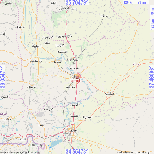
Ḩamāh GPS coordinates[2]
35° 7' 54.444" North, 36° 45' 28.188" East
| Map corner | latitude | longitude |
|---|---|---|
| Upper-left | 35.70479°, | 36.05471° |
| Center: | 35.13179°, | 36.75783° |
| Lower-right: | 34.55473°, | 37.46096° |
| Map W x H: | 127.9×127.9 km | = 79.5×79.5mi |
| max Lat: | 37.17701° ⇑50.2% North |
| Ḩamāh: | 35.13179° |
| min Lat: | ⇓49.8% South 32.39332° |
| min Long | Ḩamāh | max Long |
| 35.75572° | 36.75783° | 42.14006° |
| W 63.3%⇐ | ⇒36.7% E |
Elevation
Elevation of Ḩamāh is 270 m = 886 ft, and this is 259.1 m = 850 ft below average elevation for this country.
| Max E: |
1640 m = 5381 ft | 80.9% |
| Avg. | 529.1 m = 1736 ft | |
| Ḩamāh | 270 m = 886 ft | |
Min E: |
4 m = 13 ft | 19.1% |
See also: Ḩamāh elevation on elevation.city.
Geographical zone
Ḩamāh is located in North temperate zone (between Tropic of Cancer and the Arctic Circle). Distance of this Northern Tropic circle is 1300.4 km =808 mi to South.| Distance of | km | miles | from Ḩamāh |
|---|---|---|---|
| North Pole | 6100.8 | 3790.9 | to North |
| Arctic Circle | 3494.9 | 2171.6 | to North |
| Tropic Cancer | 1300.4 | 808 | to South |
| Equator | 3906.3 | 2427.3 | to South |


Nearby cities:
15 places around Ḩamāh: (largest is in red/bold)
• Al Ghanţū
34.9 km =21.7 mi,  189°
189°
• Ar Rastan
22.9 km =14.2 mi, 185°
• As Salamīyah
30 km =18.6 mi,  116°
116°
• Jubb Ramlah
30.9 km =19.2 mi,  286°
286°
• Kafr Lāhā
35.6 km =22.1 mi,  222°
222°
• Kafr Zaytā
30.4 km =18.9 mi,  332°
332°
• Muḩradah
21.2 km =13.2 mi,  307°
307°
• Mūrak
27.9 km =17.3 mi,  347°
347°
• Souran
17.8 km =11.1 mi,  357°
357°
• Tallbīsah
32.5 km =20.2 mi,  184°
184°
• Talldaww
35.5 km =22.1 mi, 216°
• Tremseh
27.8 km =17.3 mi,  304°
304°
• Ţayyibat al Imām
15.5 km =9.6 mi,  344°
344°
• Ḩalfāyā
19.9 km =12.4 mi,  315°
315°
• Ḩarbinafsah
24.9 km =15.5 mi,  209°
209°
Sources, notices
• [Note1] Compared only with cities in Syria existing in our database
• [Src1] Map data: © OpenStreetMap contributors (CC-BY-SA)
• [Src2] Other city data from geonames.org with taken over terms of usage.
• [Src3] Geographical zone / Annual Mean Temperature by Robert A. Rohde @ Wikipedia
