As Salamīyah geodata
As Salamīyah (Hama) is a seat of a second-order administrative division; located in Syria in Asia/Damascus (GMT+3) time zone. With population of 94,887 people, there are 12 cities with bigger population in this country. Compared to other cities in Syria, 54.4% of cities are located further ↑North; 71% of cities are located further ←West and 51.6% of cities have higher elevation than As Salamīyah. Note1


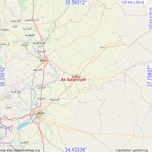
As Salamīyah GPS coordinates[2]
35° 0' 40.572" North, 37° 3' 11.664" East
| Map corner | latitude | longitude |
|---|---|---|
| Upper-left | 35.58512°, | 36.35012° |
| Center: | 35.01127°, | 37.05324° |
| Lower-right: | 34.43336°, | 37.75637° |
| Map W x H: | 128.1×128.1 km | = 79.6×79.6mi |
| max Lat: | 37.17701° ⇑54.4% North |
| As Salamīyah: | 35.01127° |
| min Lat: | ⇓45.6% South 32.39332° |
| min Long | As Salamīyah | max Long |
| 35.75572° | 37.05324° | 42.14006° |
| W 71%⇐ | ⇒29% E |
Elevation
Elevation of As Salamīyah is 461 m = 1512 ft, and this is 68.1 m = 223 ft below average elevation for this country.
| Max E: |
1640 m = 5381 ft | 51.6% |
| Avg. | 529.1 m = 1736 ft | |
| As Salamīyah | 461 m = 1512 ft | |
Min E: |
4 m = 13 ft | 48.4% |
See also: As Salamīyah elevation on elevation.city.
Geographical zone
As Salamīyah is located in North temperate zone (between Tropic of Cancer and the Arctic Circle). Distance of this Northern Tropic circle is 1287 km =799.7 mi to South.| Distance of | km | miles | from As Salamīyah |
|---|---|---|---|
| North Pole | 6114.2 | 3799.2 | to North |
| Arctic Circle | 3508.3 | 2180 | to North |
| Tropic Cancer | 1287 | 799.7 | to South |
| Equator | 3892.9 | 2418.9 | to South |


Nearby cities:
15 places around As Salamīyah: (largest is in red/bold)
• Al Ghanţū
38.8 km =24.1 mi,  237°
237°
• Al Ḩamrā’
33.9 km =21.1 mi,  5°
5°
• Ar Rastan
30.7 km =19.1 mi,  252°
252°
• As Si‘in
40.5 km =25.2 mi,  46°
46°
• Barrī ash Sharqī
13.9 km =8.6 mi,  104°
104°
• Jubb al Jarrāḩ
31.6 km =19.6 mi,  128°
128°
• Mukharram al Fawqānī
22 km =13.7 mi,  172°
172°
• Souran
41.7 km =25.9 mi,  318°
318°
• Tallbīsah
35 km =21.7 mi, 237°
• Şabbūrah
21.4 km =13.3 mi,  41°
41°
• Ţayyibat al Imām
42 km =26.1 mi,  312°
312°
• Ḩamāh
30 km =18.6 mi,  296°
296°
• Ḩarbinafsah
40.1 km =24.9 mi,  258°
258°
• ‘Ayn an Nasr
22.1 km =13.7 mi,  211°
211°
• ‘Uqayribāt
37.6 km =23.4 mi,  84°
84°
Sources, notices
• [Note1] Compared only with cities in Syria existing in our database
• [Src1] Map data: © OpenStreetMap contributors (CC-BY-SA)
• [Src2] Other city data from geonames.org with taken over terms of usage.
• [Src3] Geographical zone / Annual Mean Temperature by Robert A. Rohde @ Wikipedia
