‘Ayn an Nasr geodata
‘Ayn an Nasr (Homs) is a seat of a third-order administrative division; located in Syria in Asia/Damascus (GMT+3) time zone. In our database, there are 87 cities with bigger population. Compared to other cities in Syria, 62.5% of cities are located further ↑North; 68.2% of cities are located further ←West and 51.2% of cities have lower elevation than ‘Ayn an Nasr. Note1


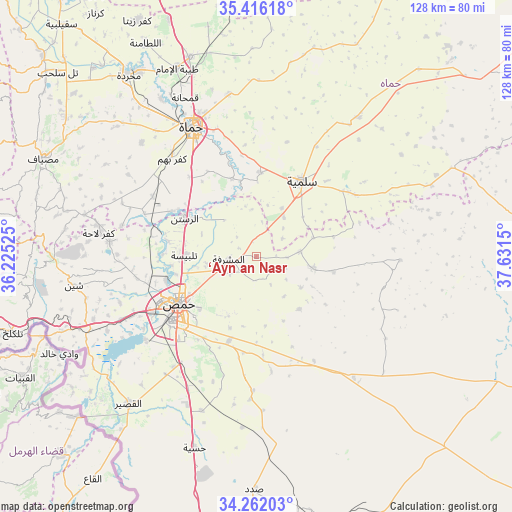
‘Ayn an Nasr GPS coordinates[2]
34° 50' 28.068" North, 36° 55' 42.132" East
| Map corner | latitude | longitude |
|---|---|---|
| Upper-left | 35.41618°, | 36.22525° |
| Center: | 34.84113°, | 36.92837° |
| Lower-right: | 34.26203°, | 37.6315° |
| Map W x H: | 128.3×128.3 km | = 79.7×79.7mi |
| max Lat: | 37.17701° ⇑62.5% North |
| ‘Ayn an Nasr: | 34.84113° |
| min Lat: | ⇓37.5% South 32.39332° |
| min Long | ‘Ayn an Nasr | max Long |
| 35.75572° | 36.92837° | 42.14006° |
| W 68.2%⇐ | ⇒31.8% E |
Elevation
Elevation of ‘Ayn an Nasr is 476 m = 1562 ft, and this is 53.1 m = 174 ft below average elevation for this country.
| Max E: |
1640 m = 5381 ft | 48.8% |
| Avg. | 529.1 m = 1736 ft | |
| ‘Ayn an Nasr | 476 m = 1562 ft | |
Min E: |
4 m = 13 ft | 51.2% |
See also: Syria elevation on elevation.city.
Geographical zone
‘Ayn an Nasr is located in North temperate zone (between Tropic of Cancer and the Arctic Circle). Distance of this Northern Tropic circle is 1268.1 km =788 mi to South.| Distance of | km | miles | from ‘Ayn an Nasr |
|---|---|---|---|
| North Pole | 6133.1 | 3810.9 | to North |
| Arctic Circle | 3527.2 | 2191.7 | to North |
| Tropic Cancer | 1268.1 | 788 | to South |
| Equator | 3874 | 2407.2 | to South |


Nearby cities:
15 places around ‘Ayn an Nasr: (largest is in red/bold)
• Al Furqlus
29.9 km =18.6 mi,  150°
150°
• Al Ghanţū
21.3 km =13.2 mi,  264°
264°
• Ar Rastan
20.2 km =12.6 mi,  298°
298°
• Ar Riqāmā
33.6 km =20.9 mi,  181°
181°
• As Salamīyah
22.1 km =13.7 mi,  31°
31°
• Barrī ash Sharqī
29.3 km =18.2 mi,  57°
57°
• Homs
22.6 km =14 mi,  235°
235°
• Jubb al Jarrāḩ
36.1 km =22.4 mi,  91°
91°
• Kafr Lāhā
39.9 km =24.8 mi,  278°
278°
• Khirbat Tīn Nūr
37.4 km =23.2 mi,  245°
245°
• Mukharram al Fawqānī
14.7 km =9.1 mi,  101°
101°
• Tallbīsah
18 km =11.2 mi,  269°
269°
• Talldaww
37.1 km =23.1 mi, 276°
• Ḩamāh
35.9 km =22.3 mi,  334°
334°
• Ḩarbinafsah
29.9 km =18.6 mi,  290°
290°
Sources, notices
• [Note1] Compared only with cities in Syria existing in our database
• [Src1] Map data: © OpenStreetMap contributors (CC-BY-SA)
• [Src2] Other city data from geonames.org with taken over terms of usage.
• [Src3] Geographical zone / Annual Mean Temperature by Robert A. Rohde @ Wikipedia
