Al Ghanţū geodata
Al Ghanţū (Homs) is a populated place; located in Syria in Asia/Damascus (GMT+3) time zone. With population of 9,412 people, there are 79 cities with bigger population in this country. Compared to other cities in Syria, 64.3% of cities are located further ↑North; 57.2% of cities are located further ←West and 53% of cities have higher elevation than Al Ghanţū. Note1


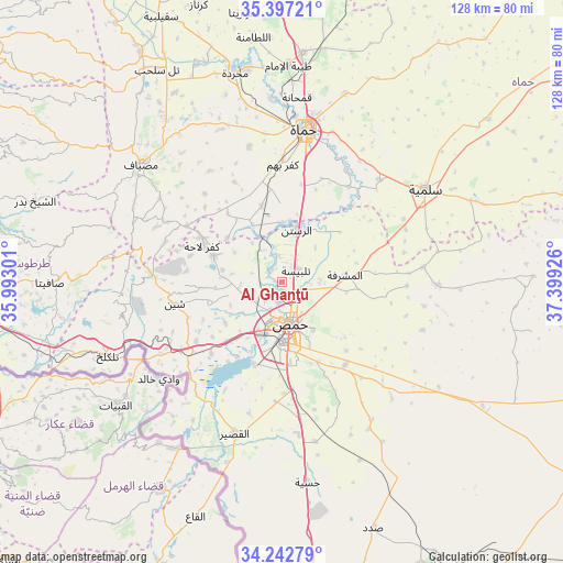
Al Ghanţū GPS coordinates[2]
34° 49' 19.272" North, 36° 41' 46.068" East
| Map corner | latitude | longitude |
|---|---|---|
| Upper-left | 35.39721°, | 35.99301° |
| Center: | 34.82202°, | 36.69613° |
| Lower-right: | 34.24279°, | 37.39926° |
| Map W x H: | 128.4×128.4 km | = 79.8×79.8mi |
| max Lat: | 37.17701° ⇑64.3% North |
| Al Ghanţū: | 34.82202° |
| min Lat: | ⇓35.7% South 32.39332° |
| min Long | Al Ghanţū | max Long |
| 35.75572° | 36.69613° | 42.14006° |
| W 57.2%⇐ | ⇒42.8% E |
Elevation
Elevation of Al Ghanţū is 455 m = 1493 ft, and this is 74.1 m = 243 ft below average elevation for this country.
| Max E: |
1640 m = 5381 ft | 53% |
| Avg. | 529.1 m = 1736 ft | |
| Al Ghanţū | 455 m = 1493 ft | |
Min E: |
4 m = 13 ft | 47% |
See also: Syria elevation on elevation.city.
Geographical zone
Al Ghanţū is located in North temperate zone (between Tropic of Cancer and the Arctic Circle). Distance of this Northern Tropic circle is 1265.9 km =786.6 mi to South.| Distance of | km | miles | from Al Ghanţū |
|---|---|---|---|
| North Pole | 6135.2 | 3812.2 | to North |
| Arctic Circle | 3529.3 | 2193 | to North |
| Tropic Cancer | 1265.9 | 786.6 | to South |
| Equator | 3871.8 | 2405.8 | to South |


Nearby cities:
15 places around Al Ghanţū: (largest is in red/bold)
• Al Qabw
22.1 km =13.7 mi,  276°
276°
• Al Ḩawāsh
34.9 km =21.7 mi,  258°
258°
• Ar Rastan
12.1 km =7.5 mi,  15°
15°
• Homs
10.9 km =6.8 mi,  166°
166°
• Kafr Lāhā
20 km =12.4 mi,  293°
293°
• Khirbat Tīn Nūr
18.5 km =11.5 mi,  223°
223°
• Mukharram al Fawqānī
35.7 km =22.2 mi,  91°
91°
• Shīn
25.3 km =15.7 mi, 259°
• Tallbīsah
3.8 km =2.4 mi,  56°
56°
• Talldaww
16.8 km =10.4 mi, 291°
• Ḩadīdah
31.9 km =19.8 mi,  238°
238°
• Ḩamāh
34.9 km =21.7 mi,  9°
9°
• Ḩarbinafsah
14.5 km =9 mi,  332°
332°
• ‘Awaj
28.2 km =17.5 mi, 289°
• ‘Ayn an Nasr
21.3 km =13.2 mi,  84°
84°
Sources, notices
• [Note1] Compared only with cities in Syria existing in our database
• [Src1] Map data: © OpenStreetMap contributors (CC-BY-SA)
• [Src2] Other city data from geonames.org with taken over terms of usage.
• [Src3] Geographical zone / Annual Mean Temperature by Robert A. Rohde @ Wikipedia
