Tallbīsah geodata
Tallbīsah (Homs) is a seat of a third-order administrative division; located in Syria in Asia/Damascus (GMT+3) time zone. With population of 38,491 people, there are 36 cities with bigger population in this country. Compared to other cities in Syria, 62.9% of cities are located further ↑North; 60.8% of cities are located further ←West and 52.7% of cities have higher elevation than Tallbīsah. Note1


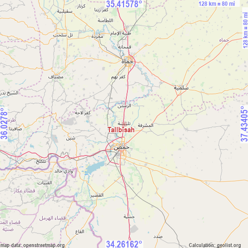
Tallbīsah GPS coordinates[2]
34° 50' 26.592" North, 36° 43' 51.312" East
| Map corner | latitude | longitude |
|---|---|---|
| Upper-left | 35.41578°, | 36.0278° |
| Center: | 34.84072°, | 36.73092° |
| Lower-right: | 34.26162°, | 37.43405° |
| Map W x H: | 128.3×128.3 km | = 79.7×79.7mi |
| max Lat: | 37.17701° ⇑62.9% North |
| Tallbīsah: | 34.84072° |
| min Lat: | ⇓37.1% South 32.39332° |
| min Long | Tallbīsah | max Long |
| 35.75572° | 36.73092° | 42.14006° |
| W 60.8%⇐ | ⇒39.2% E |
Elevation
Elevation of Tallbīsah is 460 m = 1509 ft, and this is 69.1 m = 227 ft below average elevation for this country.
| Max E: |
1640 m = 5381 ft | 52.7% |
| Avg. | 529.1 m = 1736 ft | |
| Tallbīsah | 460 m = 1509 ft | |
Min E: |
4 m = 13 ft | 47.3% |
See also: Syria elevation on elevation.city.
Geographical zone
Tallbīsah is located in North temperate zone (between Tropic of Cancer and the Arctic Circle). Distance of this Northern Tropic circle is 1268 km =787.9 mi to South.| Distance of | km | miles | from Tallbīsah |
|---|---|---|---|
| North Pole | 6133.1 | 3810.9 | to North |
| Arctic Circle | 3527.2 | 2191.7 | to North |
| Tropic Cancer | 1268 | 787.9 | to South |
| Equator | 3873.9 | 2407.1 | to South |


Nearby cities:
15 places around Tallbīsah: (largest is in red/bold)
• Al Ghanţū
3.8 km =2.4 mi,  236°
236°
• Al Qabw
25.2 km =15.7 mi,  270°
270°
• Ar Rastan
9.6 km =6 mi,  0°
0°
• As Salamīyah
35 km =21.7 mi,  57°
57°
• Homs
12.7 km =7.9 mi,  183°
183°
• Kafr Lāhā
22.3 km =13.9 mi,  285°
285°
• Khirbat Tīn Nūr
22.2 km =13.8 mi,  225°
225°
• Mukharram al Fawqānī
32.6 km =20.3 mi,  94°
94°
• Shīn
28.9 km =18 mi,  256°
256°
• Talldaww
19.3 km =12 mi,  281°
281°
• Ḩadīdah
35.7 km =22.2 mi, 238°
• Ḩamāh
32.5 km =20.2 mi, 4°
• Ḩarbinafsah
14.6 km =9.1 mi,  317°
317°
• ‘Awaj
30.7 km =19.1 mi, 283°
• ‘Ayn an Nasr
18 km =11.2 mi, 89°
Sources, notices
• [Note1] Compared only with cities in Syria existing in our database
• [Src1] Map data: © OpenStreetMap contributors (CC-BY-SA)
• [Src2] Other city data from geonames.org with taken over terms of usage.
• [Src3] Geographical zone / Annual Mean Temperature by Robert A. Rohde @ Wikipedia
