Sahnaiya geodata
Sahnaiya (Rif-dimashq) is a seat of a third-order administrative division; located in Syria in Asia/Damascus (GMT+3) time zone. In our database, there are 87 cities with bigger population. Compared to other cities in Syria, 86.2% of cities are located further ↑North; 73.9% of cities are located further →East and 79.5% of cities have lower elevation than Sahnaiya. Note1


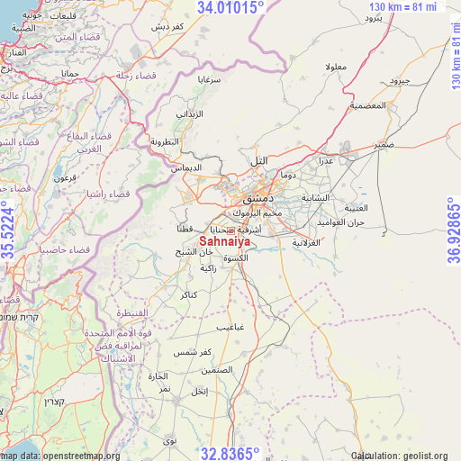
Sahnaiya GPS coordinates[2]
33° 25' 31.116" North, 36° 13' 31.872" East
| Map corner | latitude | longitude |
|---|---|---|
| Upper-left | 34.01015°, | 35.5224° |
| Center: | 33.42531°, | 36.22552° |
| Lower-right: | 32.8365°, | 36.92865° |
| Map W x H: | 130.5×130.5 km | = 81.1×81.1mi |
| max Lat: | 37.17701° ⇑86.2% North |
| Sahnaiya: | 33.42531° |
| min Lat: | ⇓13.8% South 32.39332° |
| min Long | Sahnaiya | max Long |
| 35.75572° | 36.22552° | 42.14006° |
| W 26.1%⇐ | ⇒73.9% E |
Elevation
Elevation of Sahnaiya is 705 m = 2313 ft, and this is 175.9 m = 577 ft above average elevation for this country.
| Max E: |
1640 m = 5381 ft | 20.5% |
| Sahnaiya | 705 m 2313 ft | |
| Avg. | 529.1 m = 1736 ft | |
Min E: |
4 m = 13 ft | 79.5% |
See also: Syria elevation on elevation.city.
Geographical zone
Sahnaiya is located in North temperate zone (between Tropic of Cancer and the Arctic Circle). Distance of this Northern Tropic circle is 1110.6 km =690.1 mi to South.| Distance of | km | miles | from Sahnaiya |
|---|---|---|---|
| North Pole | 6290.5 | 3908.7 | to North |
| Arctic Circle | 3684.6 | 2289.5 | to North |
| Tropic Cancer | 1110.6 | 690.1 | to South |
| Equator | 3716.5 | 2309.3 | to South |


Nearby cities:
15 places around Sahnaiya: (largest is in red/bold)
• Al Ghizlānīyah
21.5 km =13.4 mi,  98°
98°
• Al Kiswah
7.6 km =4.7 mi,  168°
168°
• Al Mulayḩah
15.4 km =9.6 mi,  64°
64°
• Al Ḩajar al Aswad
8.1 km =5 mi, 63°
• Babīlā
11 km =6.8 mi, 62°
• Damascus
11.2 km =7 mi,  32°
32°
• Dayr al ‘Aşāfīr
18.6 km =11.6 mi,  76°
76°
• Dārayyā
3.7 km =2.3 mi,  10°
10°
• Jaramānā
13.1 km =8.1 mi, 58°
• Kafr Baţnā
16.7 km =10.4 mi,  54°
54°
• Qadsayyā
13.7 km =8.5 mi,  356°
356°
• Qaţanā
13.7 km =8.5 mi,  275°
275°
• Ḩarastā
19.7 km =12.2 mi,  41°
41°
• ‘Ayn al Fījah
21.5 km =13.4 mi,  349°
349°
• ‘Irbīn
18 km =11.2 mi, 46°
Sources, notices
• [Note1] Compared only with cities in Syria existing in our database
• [Src1] Map data: © OpenStreetMap contributors (CC-BY-SA)
• [Src2] Other city data from geonames.org with taken over terms of usage.
• [Src3] Geographical zone / Annual Mean Temperature by Robert A. Rohde @ Wikipedia
