Jaramānā geodata
Jaramānā (Rif-dimashq) is a seat of a third-order administrative division; located in Syria in Asia/Damascus (GMT+3) time zone. In our database, there are 87 cities with bigger population. Compared to other cities in Syria, 83.4% of cities are located further ↑North; 65.7% of cities are located further →East and 75.3% of cities have lower elevation than Jaramānā. Note1


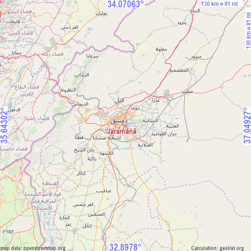
Jaramānā GPS coordinates[2]
33° 29' 10.32" North, 36° 20' 46.104" East
| Map corner | latitude | longitude |
|---|---|---|
| Upper-left | 34.07063°, | 35.64302° |
| Center: | 33.4862°, | 36.34614° |
| Lower-right: | 32.8978°, | 37.04927° |
| Map W x H: | 130.4×130.4 km | = 81×81mi |
| max Lat: | 37.17701° ⇑83.4% North |
| Jaramānā: | 33.4862° |
| min Lat: | ⇓16.6% South 32.39332° |
| min Long | Jaramānā | max Long |
| 35.75572° | 36.34614° | 42.14006° |
| W 34.3%⇐ | ⇒65.7% E |
Elevation
Elevation of Jaramānā is 670 m = 2198 ft, and this is 140.9 m = 462 ft above average elevation for this country.
| Max E: |
1640 m = 5381 ft | 24.7% |
| Jaramānā | 670 m 2198 ft | |
| Avg. | 529.1 m = 1736 ft | |
Min E: |
4 m = 13 ft | 75.3% |
See also: Syria elevation on elevation.city.
Geographical zone
Jaramānā is located in North temperate zone (between Tropic of Cancer and the Arctic Circle). Distance of this Northern Tropic circle is 1117.4 km =694.3 mi to South.| Distance of | km | miles | from Jaramānā |
|---|---|---|---|
| North Pole | 6283.7 | 3904.5 | to North |
| Arctic Circle | 3677.9 | 2285.3 | to North |
| Tropic Cancer | 1117.4 | 694.3 | to South |
| Equator | 3723.3 | 2313.6 | to South |


Nearby cities:
15 places around Jaramānā: (largest is in red/bold)
• Al Ghizlānīyah
14.2 km =8.8 mi,  134°
134°
• Al Mulayḩah
2.7 km =1.7 mi,  92°
92°
• Al Ḩajar al Aswad
5 km =3.1 mi,  230°
230°
• An Nashābīyah
13.2 km =8.2 mi,  78°
78°
• At Tall
14.2 km =8.8 mi,  346°
346°
• Babīlā
2.2 km =1.4 mi,  220°
220°
• Damascus
5.7 km =3.5 mi,  297°
297°
• Dayr al ‘Aşāfīr
7.3 km =4.5 mi,  108°
108°
• Douma
10.9 km =6.8 mi,  28°
28°
• Dārayyā
11 km =6.8 mi,  253°
253°
• Kafr Baţnā
3.8 km =2.4 mi,  41°
41°
• Qadsayyā
13.9 km =8.6 mi, 299°
• Sahnaiya
13.1 km =8.1 mi,  238°
238°
• Ḩarastā
8.3 km =5.2 mi,  12°
12°
• ‘Irbīn
6 km =3.7 mi,  18°
18°
Sources, notices
• [Note1] Compared only with cities in Syria existing in our database
• [Src1] Map data: © OpenStreetMap contributors (CC-BY-SA)
• [Src2] Other city data from geonames.org with taken over terms of usage.
• [Src3] Geographical zone / Annual Mean Temperature by Robert A. Rohde @ Wikipedia
