Qadsayyā geodata
Qadsayyā (Rif-dimashq) is a seat of a third-order administrative division; located in Syria in Asia/Damascus (GMT+3) time zone. In our database, there are 87 cities with bigger population. Compared to other cities in Syria, 81.3% of cities are located further ↑North; 74.6% of cities are located further →East and 83.4% of cities have lower elevation than Qadsayyā. Note1


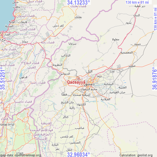
Qadsayyā GPS coordinates[2]
33° 32' 53.952" North, 36° 12' 56.268" East
| Map corner | latitude | longitude |
|---|---|---|
| Upper-left | 34.13233°, | 35.51251° |
| Center: | 33.54832°, | 36.21563° |
| Lower-right: | 32.96034°, | 36.91876° |
| Map W x H: | 130.3×130.3 km | = 81×81mi |
| max Lat: | 37.17701° ⇑81.3% North |
| Qadsayyā: | 33.54832° |
| min Lat: | ⇓18.7% South 32.39332° |
| min Long | Qadsayyā | max Long |
| 35.75572° | 36.21563° | 42.14006° |
| W 25.4%⇐ | ⇒74.6% E |
Elevation
Elevation of Qadsayyā is 791 m = 2595 ft, and this is 261.9 m = 859 ft above average elevation for this country.
| Max E: |
1640 m = 5381 ft | 16.6% |
| Qadsayyā | 791 m 2595 ft | |
| Avg. | 529.1 m = 1736 ft | |
Min E: |
4 m = 13 ft | 83.4% |
See also: Syria elevation on elevation.city.
Geographical zone
Qadsayyā is located in North temperate zone (between Tropic of Cancer and the Arctic Circle). Distance of this Northern Tropic circle is 1124.3 km =698.6 mi to South.| Distance of | km | miles | from Qadsayyā |
|---|---|---|---|
| North Pole | 6276.8 | 3900.2 | to North |
| Arctic Circle | 3671 | 2281.1 | to North |
| Tropic Cancer | 1124.3 | 698.6 | to South |
| Equator | 3730.2 | 2317.8 | to South |


Nearby cities:
15 places around Qadsayyā: (largest is in red/bold)
• Ad Dīmās
12.2 km =7.6 mi,  290°
290°
• Al Mulayḩah
16.4 km =10.2 mi,  115°
115°
• Al Ḩajar al Aswad
13 km =8.1 mi,  140°
140°
• At Tall
11.2 km =7 mi,  51°
51°
• Babīlā
13.7 km =8.5 mi,  128°
128°
• Damascus
8.2 km =5.1 mi, 121°
• Douma
17.5 km =10.9 mi,  81°
81°
• Dārayyā
10.1 km =6.3 mi,  171°
171°
• Jaramānā
13.9 km =8.6 mi, 119°
• Kafr Baţnā
15.1 km =9.4 mi,  105°
105°
• Qaţanā
17.7 km =11 mi,  225°
225°
• Sahnaiya
13.7 km =8.5 mi,  176°
176°
• Ḩarastā
13.9 km =8.6 mi,  85°
85°
• ‘Ayn al Fījah
8 km =5 mi,  337°
337°
• ‘Irbīn
14 km =8.7 mi,  95°
95°
Sources, notices
• [Note1] Compared only with cities in Syria existing in our database
• [Src1] Map data: © OpenStreetMap contributors (CC-BY-SA)
• [Src2] Other city data from geonames.org with taken over terms of usage.
• [Src3] Geographical zone / Annual Mean Temperature by Robert A. Rohde @ Wikipedia
