Ḩarastā geodata
Ḩarastā (Rif-dimashq) is a seat of a third-order administrative division; located in Syria in Asia/Damascus (GMT+3) time zone. With population of 37,348 people, there are 37 cities with bigger population in this country. Compared to other cities in Syria, 80.9% of cities are located further ↑North; 65.4% of cities are located further →East and 79.9% of cities have lower elevation than Ḩarastā. Note1


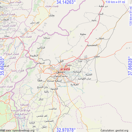
Ḩarastā GPS coordinates[2]
33° 33' 31.284" North, 36° 21' 54.54" East
| Map corner | latitude | longitude |
|---|---|---|
| Upper-left | 34.14263°, | 35.66203° |
| Center: | 33.55869°, | 36.36515° |
| Lower-right: | 32.97078°, | 37.06828° |
| Map W x H: | 130.3×130.3 km | = 81×81mi |
| max Lat: | 37.17701° ⇑80.9% North |
| Ḩarastā: | 33.55869° |
| min Lat: | ⇓19.1% South 32.39332° |
| min Long | Ḩarastā | max Long |
| 35.75572° | 36.36515° | 42.14006° |
| W 34.6%⇐ | ⇒65.4% E |
Elevation
Elevation of Ḩarastā is 710 m = 2329 ft, and this is 180.9 m = 594 ft above average elevation for this country.
| Max E: |
1640 m = 5381 ft | 20.1% |
| Ḩarastā | 710 m 2329 ft | |
| Avg. | 529.1 m = 1736 ft | |
Min E: |
4 m = 13 ft | 79.9% |
See also: Syria elevation on elevation.city.
Geographical zone
Ḩarastā is located in North temperate zone (between Tropic of Cancer and the Arctic Circle). Distance of this Northern Tropic circle is 1125.5 km =699.4 mi to South.| Distance of | km | miles | from Ḩarastā |
|---|---|---|---|
| North Pole | 6275.7 | 3899.5 | to North |
| Arctic Circle | 3669.8 | 2280.3 | to North |
| Tropic Cancer | 1125.5 | 699.4 | to South |
| Equator | 3731.4 | 2318.6 | to South |


Nearby cities:
15 places around Ḩarastā: (largest is in red/bold)
• Al Mulayḩah
8.2 km =5.1 mi,  173°
173°
• Al Ḩajar al Aswad
12.6 km =7.8 mi,  206°
206°
• An Nashābīyah
12.4 km =7.7 mi,  115°
115°
• At Tall
7.6 km =4.7 mi,  318°
318°
• Babīlā
10.3 km =6.4 mi,  198°
198°
• Damascus
8.7 km =5.4 mi,  231°
231°
• Dayr al ‘Aşāfīr
11.5 km =7.1 mi,  153°
153°
• Douma
3.8 km =2.4 mi,  67°
67°
• Dārayyā
16.6 km =10.3 mi, 227°
• Jaramānā
8.3 km =5.2 mi,  192°
192°
• Kafr Baţnā
5.3 km =3.3 mi, 172°
• Qadsayyā
13.9 km =8.6 mi,  265°
265°
• Şaydnāyā
15.1 km =9.4 mi,  2°
2°
• ‘Ayn al Fījah
18 km =11.2 mi,  290°
290°
• ‘Irbīn
2.4 km =1.5 mi,  177°
177°
Sources, notices
• [Note1] Compared only with cities in Syria existing in our database
• [Src1] Map data: © OpenStreetMap contributors (CC-BY-SA)
• [Src2] Other city data from geonames.org with taken over terms of usage.
• [Src3] Geographical zone / Annual Mean Temperature by Robert A. Rohde @ Wikipedia
