Sulūk geodata
Sulūk (Ar-Raqqah) is a seat of a third-order administrative division; located in Syria in Asia/Damascus (GMT+3) time zone. In our database, there are 87 cities with bigger population. Compared to other cities in Syria, 92.9% of cities are located further ↓South; 88.3% of cities are located further ←West and 72.4% of cities have higher elevation than Sulūk. Note1


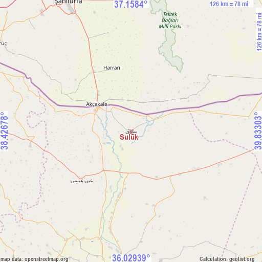
Sulūk GPS coordinates[2]
36° 35' 45.456" North, 39° 7' 47.64" East
| Map corner | latitude | longitude |
|---|---|---|
| Upper-left | 37.1584°, | 38.42678° |
| Center: | 36.59596°, | 39.1299° |
| Lower-right: | 36.02939°, | 39.83303° |
| Map W x H: | 125.5×125.5 km | = 78×78mi |
| max Lat: | 37.17701° ⇑7.1% North |
| Sulūk: | 36.59596° |
| min Lat: | ⇓92.9% South 32.39332° |
| min Long | Sulūk | max Long |
| 35.75572° | 39.1299° | 42.14006° |
| W 88.3%⇐ | ⇒11.7% E |
Elevation
Elevation of Sulūk is 343 m = 1125 ft, and this is 186.1 m = 611 ft below average elevation for this country.
| Max E: |
1640 m = 5381 ft | 72.4% |
| Avg. | 529.1 m = 1736 ft | |
| Sulūk | 343 m = 1125 ft | |
Min E: |
4 m = 13 ft | 27.6% |
See also: Syria elevation on elevation.city.
Geographical zone
Sulūk is located in North temperate zone (between Tropic of Cancer and the Arctic Circle). Distance of this Northern Tropic circle is 1463.2 km =909.2 mi to South.| Distance of | km | miles | from Sulūk |
|---|---|---|---|
| North Pole | 5938 | 3689.7 | to North |
| Arctic Circle | 3332.1 | 2070.5 | to North |
| Tropic Cancer | 1463.2 | 909.2 | to South |
| Equator | 4069.1 | 2528.4 | to South |


Nearby cities:
15 places around Sulūk: (largest is in red/bold)
• Abū Qalqal
92 km =57.2 mi,  258°
258°
• Al Jarnīyah
93.7 km =58.2 mi,  238°
238°
• Al Karāmah
82 km =51 mi,  170°
170°
• Al Manşūrah
91 km =56.5 mi,  202°
202°
• Ar Raqqah
72.3 km =44.9 mi,  188°
188°
• As Sabkhah
88 km =54.7 mi, 172°
• Ath Thawrah
99.2 km =61.6 mi,  211°
211°
• Jarābulus
102.7 km =63.8 mi,  283°
283°
• Ma‘dān
102.5 km =63.7 mi,  155°
155°
• Ra’s al ‘Ayn
88.5 km =55 mi,  71°
71°
• Shuyūkh Taḩtānī
95.5 km =59.3 mi, 280°
• Tall Abyaḑ
19.3 km =12 mi,  305°
305°
• Şirrīn ash Shamālīyah
74.3 km =46.2 mi,  269°
269°
• ‘Ayn al ‘Arab
76.6 km =47.6 mi,  295°
295°
• ‘Ayn ‘Īsá
33.5 km =20.8 mi,  225°
225°
Sources, notices
• [Note1] Compared only with cities in Syria existing in our database
• [Src1] Map data: © OpenStreetMap contributors (CC-BY-SA)
• [Src2] Other city data from geonames.org with taken over terms of usage.
• [Src3] Geographical zone / Annual Mean Temperature by Robert A. Rohde @ Wikipedia
