‘Ayn Ḩalāqīm geodata
‘Ayn Ḩalāqīm (Hama) is a seat of a third-order administrative division; located in Syria in Asia/Damascus (GMT+3) time zone. In our database, there are 87 cities with bigger population. Compared to other cities in Syria, 56.5% of cities are located further ↑North; 67.5% of cities are located further →East and 67.1% of cities have lower elevation than ‘Ayn Ḩalāqīm. Note1


‘Ayn Ḩalāqīm GPS coordinates[2]
34° 56' 23.928" North, 36° 19' 19.632" East
| Map corner | latitude | longitude |
|---|---|---|
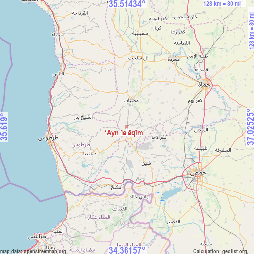
| Upper-left | 35.51434°, | 35.619° |
| Center: | 34.93998°, | 36.32212° |
| Lower-right: | 34.36157°, | 37.02525° |
| Map W x H: | 128.2×128.2 km | = 79.7×79.7mi |
| max Lat: | 37.17701° ⇑56.5% North |
| ‘Ayn Ḩalāqīm: | 34.93998° |
| min Lat: | ⇓43.5% South 32.39332° |
| min Long | ‘Ayn Ḩalāq | max Long |
| 35.75572° | 36.32212° | 42.14006° |
| W 32.5%⇐ | ⇒67.5% E |
Elevation
Elevation of ‘Ayn Ḩalāqīm is 596 m = 1955 ft, and this is 66.9 m = 219 ft above average elevation for this country.
| Max E: |
1640 m = 5381 ft | 32.9% |
| ‘Ayn Ḩalāqīm | 596 m 1955 ft | |
| Avg. | 529.1 m = 1736 ft | |
Min E: |
4 m = 13 ft | 67.1% |
See also: Syria elevation on elevation.city.
Geographical zone
‘Ayn Ḩalāqīm is located in North temperate zone (between Tropic of Cancer and the Arctic Circle). Distance of this Northern Tropic circle is 1279 km =794.7 mi to South.| Distance of | km | miles | from ‘Ayn Ḩalāqīm |
|---|---|---|---|
| North Pole | 6122.1 | 3804.1 | to North |
| Arctic Circle | 3516.2 | 2184.9 | to North |
| Tropic Cancer | 1279 | 794.7 | to South |
| Equator | 3885 | 2414 | to South |


Nearby cities:
15 places around ‘Ayn Ḩalāqīm: (largest is in red/bold)
• Ad Duraykīsh
17.1 km =10.6 mi,  253°
253°
• Al Bāriqīyah
15 km =9.3 mi,  214°
214°
• Al Qabw
16.2 km =10.1 mi,  131°
131°
• An Nāşirah
17.3 km =10.7 mi,  191°
191°
• Brummānat al Mashāyikh
16.3 km =10.1 mi,  302°
302°
• Duwayr Raslān
12.8 km =8 mi,  274°
274°
• Junaynat Raslān
18.1 km =11.2 mi, 265°
• Kaff al-Jaa
19.4 km =12.1 mi,  327°
327°
• Kafr Lāhā
16.6 km =10.3 mi,  107°
107°
• Mashtá al Ḩulw
9.7 km =6 mi,  221°
221°
• Maşyāf
14 km =8.7 mi,  6°
6°
• Sabbah
8.8 km =5.5 mi,  242°
242°
• Talldaww
19.7 km =12.2 mi, 111°
• Wādī al ‘Uyūn
14.1 km =8.8 mi, 298°
• ‘Awaj
8.4 km =5.2 mi,  116°
116°
Sources, notices
• [Note1] Compared only with cities in Syria existing in our database
• [Src1] Map data: © OpenStreetMap contributors (CC-BY-SA)
• [Src2] Other city data from geonames.org with taken over terms of usage.
• [Src3] Geographical zone / Annual Mean Temperature by Robert A. Rohde @ Wikipedia
