‘Awaj geodata
‘Awaj (Hama) is a seat of a third-order administrative division; located in Syria in Asia/Damascus (GMT+3) time zone. In our database, there are 87 cities with bigger population. Compared to other cities in Syria, 58.3% of cities are located further ↑North; 60.8% of cities are located further →East and 68.6% of cities have lower elevation than ‘Awaj. Note1


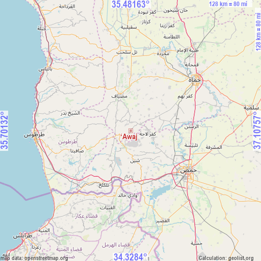
‘Awaj GPS coordinates[2]
34° 54' 25.344" North, 36° 24' 15.984" East
| Map corner | latitude | longitude |
|---|---|---|
| Upper-left | 35.48163°, | 35.70132° |
| Center: | 34.90704°, | 36.40444° |
| Lower-right: | 34.3284°, | 37.10757° |
| Map W x H: | 128.2×128.2 km | = 79.7×79.7mi |
| max Lat: | 37.17701° ⇑58.3% North |
| ‘Awaj: | 34.90704° |
| min Lat: | ⇓41.7% South 32.39332° |
| min Long | ‘Awaj | max Long |
| 35.75572° | 36.40444° | 42.14006° |
| W 39.2%⇐ | ⇒60.8% E |
Elevation
Elevation of ‘Awaj is 611 m = 2005 ft, and this is 81.9 m = 269 ft above average elevation for this country.
| Max E: |
1640 m = 5381 ft | 31.4% |
| ‘Awaj | 611 m 2005 ft | |
| Avg. | 529.1 m = 1736 ft | |
Min E: |
4 m = 13 ft | 68.6% |
See also: Syria elevation on elevation.city.
Geographical zone
‘Awaj is located in North temperate zone (between Tropic of Cancer and the Arctic Circle). Distance of this Northern Tropic circle is 1275.4 km =792.5 mi to South.| Distance of | km | miles | from ‘Awaj |
|---|---|---|---|
| North Pole | 6125.8 | 3806.4 | to North |
| Arctic Circle | 3519.9 | 2187.2 | to North |
| Tropic Cancer | 1275.4 | 792.5 | to South |
| Equator | 3881.3 | 2411.7 | to South |


Nearby cities:
15 places around ‘Awaj: (largest is in red/bold)
• Ad Duraykīsh
23.9 km =14.9 mi,  266°
266°
• Al Bāriqīyah
18.2 km =11.3 mi,  241°
241°
• Al Qabw
8.5 km =5.3 mi,  147°
147°
• Al Ḩawāsh
18 km =11.2 mi,  204°
204°
• An Nāşirah
17.1 km =10.6 mi,  219°
219°
• Duwayr Raslān
20.8 km =12.9 mi,  282°
282°
• Kafr Lāhā
8.4 km =5.2 mi,  99°
99°
• Mashtá al Ḩulw
14.5 km =9 mi,  255°
255°
• Maşyāf
18.5 km =11.5 mi,  341°
341°
• Sabbah
15.3 km =9.5 mi, 268°
• Shīn
14.4 km =8.9 mi,  172°
172°
• Talldaww
11.4 km =7.1 mi,  107°
107°
• Wādī al ‘Uyūn
22.4 km =13.9 mi,  297°
297°
• Ḩarbinafsah
20.2 km =12.6 mi,  80°
80°
• ‘Ayn Ḩalāqīm
8.4 km =5.2 mi, 296°
Sources, notices
• [Note1] Compared only with cities in Syria existing in our database
• [Src1] Map data: © OpenStreetMap contributors (CC-BY-SA)
• [Src2] Other city data from geonames.org with taken over terms of usage.
• [Src3] Geographical zone / Annual Mean Temperature by Robert A. Rohde @ Wikipedia
