Kafranbel geodata
Kafranbel (Idlib) is a seat of a third-order administrative division; located in Syria in Asia/Damascus (GMT+3) time zone. With population of 45,652 people, there are 30 cities with bigger population in this country. Compared to other cities in Syria, 66.1% of cities are located further ↓South; 52.3% of cities are located further →East and 71.7% of cities have lower elevation than Kafranbel. Note1


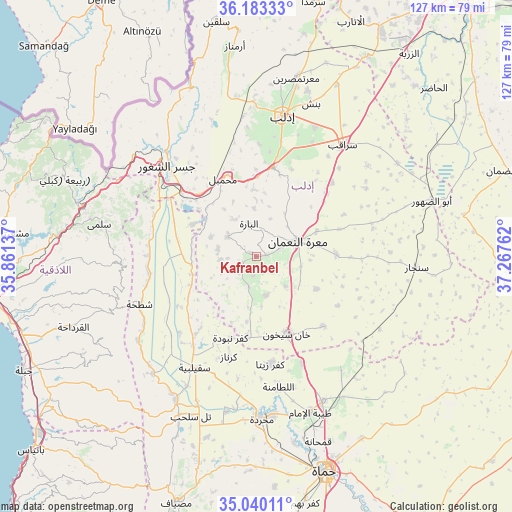
Kafranbel GPS coordinates[2]
35° 36' 49.536" North, 36° 33' 52.164" East
| Map corner | latitude | longitude |
|---|---|---|
| Upper-left | 36.18333°, | 35.86137° |
| Center: | 35.61376°, | 36.56449° |
| Lower-right: | 35.04011°, | 37.26762° |
| Map W x H: | 127.1×127.1 km | = 79×79mi |
| max Lat: | 37.17701° ⇑33.9% North |
| Kafranbel: | 35.61376° |
| min Lat: | ⇓66.1% South 32.39332° |
| min Long | Kafranbel | max Long |
| 35.75572° | 36.56449° | 42.14006° |
| W 47.7%⇐ | ⇒52.3% E |
Elevation
Elevation of Kafranbel is 643 m = 2110 ft, and this is 113.9 m = 374 ft above average elevation for this country.
| Max E: |
1640 m = 5381 ft | 28.3% |
| Kafranbel | 643 m 2110 ft | |
| Avg. | 529.1 m = 1736 ft | |
Min E: |
4 m = 13 ft | 71.7% |
See also: Kafranbel elevation on elevation.city.
Geographical zone
Kafranbel is located in North temperate zone (between Tropic of Cancer and the Arctic Circle). Distance of this Northern Tropic circle is 1354 km =841.3 mi to South.| Distance of | km | miles | from Kafranbel |
|---|---|---|---|
| North Pole | 6047.2 | 3757.6 | to North |
| Arctic Circle | 3441.3 | 2138.3 | to North |
| Tropic Cancer | 1354 | 841.3 | to South |
| Equator | 3959.9 | 2460.6 | to South |


Nearby cities:
15 places around Kafranbel: (largest is in red/bold)
• Arīḩā
22.6 km =14 mi,  10°
10°
• As Suqaylibīyah
31.5 km =19.6 mi,  209°
209°
• At Tamāni‘ah
24 km =14.9 mi,  136°
136°
• Az Ziyārah
21.9 km =13.6 mi,  291°
291°
• Iḩsim
11.9 km =7.4 mi,  356°
356°
• Jisr ash Shughūr
31.4 km =19.5 mi,  315°
315°
• Kafr Zaytā
26.9 km =16.7 mi,  172°
172°
• Khān Shaykhūn
20.6 km =12.8 mi,  157°
157°
• Kurnāz
25.9 km =16.1 mi,  195°
195°
• Ma‘arrat an Nu‘mān
10.9 km =6.8 mi,  69°
69°
• Muḩambal
21 km =13 mi,  336°
336°
• Mūrak
28.7 km =17.8 mi, 156°
• Qal‘at al Maḑīq
27.1 km =16.8 mi,  215°
215°
• Shaţḩah
31.4 km =19.5 mi,  247°
247°
• Ḩīsh
10.2 km =6.3 mi, 135°
Sources, notices
• [Note1] Compared only with cities in Syria existing in our database
• [Src1] Map data: © OpenStreetMap contributors (CC-BY-SA)
• [Src2] Other city data from geonames.org with taken over terms of usage.
• [Src3] Geographical zone / Annual Mean Temperature by Robert A. Rohde @ Wikipedia
