Atakpamé geodata
Atakpamé (Plateaux) is a seat of a first-order administrative division; located in Togo in Africa/Lome (GMT+0) time zone. With population of 80,683 people, there are 3 cities with bigger population in this country. Compared to other cities in Togo, 60% of cities are located further ↑North; 55% of cities are located further →East and 70% of cities have lower elevation than Atakpamé. Note1


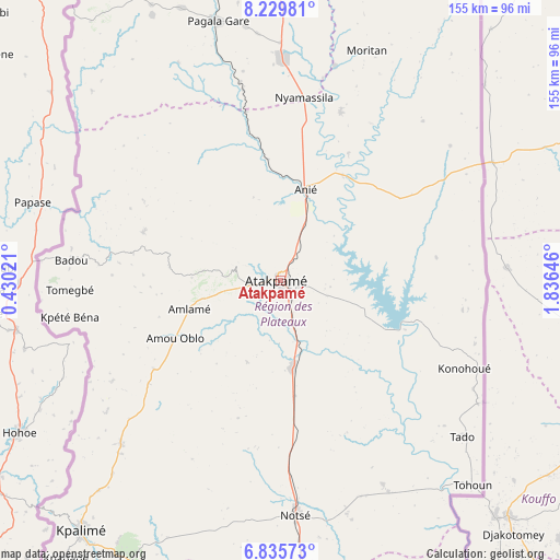
Atakpamé GPS coordinates[2]
7° 31' 59.988" North, 1° 7' 59.988" East
| Map corner | latitude | longitude |
|---|---|---|
| Upper-left | 8.22981°, | 0.43021° |
| Center: | 7.53333°, | 1.13333° |
| Lower-right: | 6.83573°, | 1.83646° |
| Map W x H: | 155×155 km | = 96.3×96.3mi |
| max Lat: | 10.86225° ⇑60% North |
| Atakpamé: | 7.53333° |
| min Lat: | ⇓40% South 6.12874° |
| min Long | Atakpamé | max Long |
| 0.20762° | 1.13333° | 1.5919° |
| W 45%⇐ | ⇒55% E |
Elevation
Elevation of Atakpamé is 361 m = 1184 ft, and this is 93.9 m = 308 ft above average elevation for this country.
| Max E: |
608 m = 1995 ft | 30% |
| Atakpamé | 361 m 1184 ft | |
| Avg. | 267.1 m = 876 ft | |
Min E: |
5 m = 16 ft | 70% |
See also: Atakpamé elevation on elevation.city.
Geographical zone
Atakpamé is located in North Torrid zone (between Equator and Tropic of Cancer). Distance of Equator is 837.6 km =520.5 mi to South.| Distance of | km | miles | from Atakpamé |
|---|---|---|---|
| North Pole | 9169.4 | 5697.6 | to North |
| Arctic Circle | 6563.5 | 4078.4 | to North |
| Tropic Cancer | 1768.3 | 1098.8 | to North |
| Equator | 837.6 | 520.5 | to South |


Nearby cities:
15 places around Atakpamé: (largest is in red/bold)
• Amlamé
26.8 km =16.7 mi,  253°
253°
• Aného
153.7 km =95.5 mi,  160°
160°
• Badou
59 km =36.7 mi,  275°
275°
• Bafilo
202.5 km =125.8 mi,  4°
4°
• Bassar
194.8 km =121 mi,  348°
348°
• Kara
224.4 km =139.4 mi, 1°
• Kpalimé
89.4 km =55.6 mi,  218°
218°
• Lomé
156.5 km =97.2 mi,  176°
176°
• Notsé
65 km =40.4 mi, 176°
• Sokodé
161.2 km =100.2 mi, 0°
• Sotouboua
115.7 km =71.9 mi, 351°
• Tabligbo
113.1 km =70.3 mi, 159°
• Tchamba
169.7 km =105.4 mi,  10°
10°
• Tsévié
123.4 km =76.7 mi, 175°
• Vogan
140.5 km =87.3 mi, 161°
Sources, notices
• [Note1] Compared only with cities in Togo existing in our database
• [Src1] Map data: © OpenStreetMap contributors (CC-BY-SA)
• [Src2] Other city data from geonames.org with taken over terms of usage.
• [Src3] Geographical zone / Annual Mean Temperature by Robert A. Rohde @ Wikipedia
