Bassar geodata
Bassar (Kara) is a populated place; located in Togo in Africa/Lome (GMT+0) time zone. With population of 61,845 people, there are 5 cities with bigger population in this country. Compared to other cities in Togo, 65% of cities are located further ↓South; 80% of cities are located further →East and 80% of cities have lower elevation than Bassar. Note1


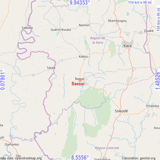
Bassar GPS coordinates[2]
9° 15' 0.9" North, 0° 46' 55.668" East
| Map corner | latitude | longitude |
|---|---|---|
| Upper-left | 9.94353°, | 0.07901° |
| Center: | 9.25025°, | 0.78213° |
| Lower-right: | 8.5556°, | 1.48526° |
| Map W x H: | 154.3×154.3 km | = 95.9×95.9mi |
| max Lat: | 10.86225° ⇑35% North |
| Bassar: | 9.25025° |
| min Lat: | ⇓65% South 6.12874° |
| min Long | Bassar | max Long |
| 0.20762° | 0.78213° | 1.5919° |
| W 20%⇐ | ⇒80% E |
Elevation
Elevation of Bassar is 388 m = 1273 ft, and this is 120.9 m = 397 ft above average elevation for this country.
| Max E: |
608 m = 1995 ft | 20% |
| Bassar | 388 m 1273 ft | |
| Avg. | 267.1 m = 876 ft | |
Min E: |
5 m = 16 ft | 80% |
See also: Bassar elevation on elevation.city.
Geographical zone
Bassar is located in North Torrid zone (between Equator and Tropic of Cancer). Distance of Equator is 1028.5 km =639.1 mi to South.| Distance of | km | miles | from Bassar |
|---|---|---|---|
| North Pole | 8978.5 | 5579 | to North |
| Arctic Circle | 6372.6 | 3959.7 | to North |
| Tropic Cancer | 1577.4 | 980.2 | to North |
| Equator | 1028.5 | 639.1 | to South |


Nearby cities:
15 places around Bassar: (largest is in red/bold)
• Amlamé
198.7 km =123.5 mi,  176°
176°
• Atakpamé
194.8 km =121 mi,  168°
168°
• Badou
186.4 km =115.8 mi,  186°
186°
• Bafilo
54.3 km =33.7 mi,  78°
78°
• Dapaong
190 km =118.1 mi,  340°
340°
• Kandé
83.8 km =52.1 mi,  20°
20°
• Kara
55.5 km =34.5 mi,  52°
52°
• Kpalimé
261.8 km =162.7 mi, 183°
• Niamtougou
67.6 km =42 mi,  31°
31°
• Notsé
259.2 km =161.1 mi, 170°
• Pagouda
81.8 km =50.8 mi, 46°
• Sansanné-Mango
127.9 km =79.5 mi, 344°
• Sokodé
48.7 km =30.3 mi,  127°
127°
• Sotouboua
79.5 km =49.4 mi,  163°
163°
• Tchamba
73.7 km =45.8 mi,  109°
109°
Sources, notices
• [Note1] Compared only with cities in Togo existing in our database
• [Src1] Map data: © OpenStreetMap contributors (CC-BY-SA)
• [Src2] Other city data from geonames.org with taken over terms of usage.
• [Src3] Geographical zone / Annual Mean Temperature by Robert A. Rohde @ Wikipedia
