Sotouboua geodata
Sotouboua (Centrale) is a populated place; located in Togo in Africa/Lome (GMT+0) time zone. With population of 21,054 people, there are 15 cities with bigger population in this country. Compared to other cities in Togo, 50% of cities are located further ↓South; 70% of cities are located further →East and 75% of cities have lower elevation than Sotouboua. Note1


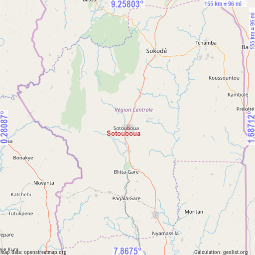
Sotouboua GPS coordinates[2]
8° 33' 48.24" North, 0° 59' 2.364" East
| Map corner | latitude | longitude |
|---|---|---|
| Upper-left | 9.25803°, | 0.28087° |
| Center: | 8.5634°, | 0.98399° |
| Lower-right: | 7.8675°, | 1.68712° |
| Map W x H: | 154.6×154.6 km | = 96.1×96.1mi |
| max Lat: | 10.86225° ⇑50% North |
| Sotouboua: | 8.5634° |
| min Lat: | ⇓50% South 6.12874° |
| min Long | Sotouboua | max Long |
| 0.20762° | 0.98399° | 1.5919° |
| W 30%⇐ | ⇒70% E |
Elevation
Elevation of Sotouboua is 380 m = 1247 ft, and this is 112.9 m = 370 ft above average elevation for this country.
| Max E: |
608 m = 1995 ft | 25% |
| Sotouboua | 380 m 1247 ft | |
| Avg. | 267.1 m = 876 ft | |
Min E: |
5 m = 16 ft | 75% |
See also: Togo elevation on elevation.city.
Geographical zone
Sotouboua is located in North Torrid zone (between Equator and Tropic of Cancer). Distance of Equator is 952.2 km =591.7 mi to South.| Distance of | km | miles | from Sotouboua |
|---|---|---|---|
| North Pole | 9054.9 | 5626.5 | to North |
| Arctic Circle | 6449 | 4007.2 | to North |
| Tropic Cancer | 1653.8 | 1027.6 | to North |
| Equator | 952.2 | 591.7 | to South |


Nearby cities:
15 places around Sotouboua: (largest is in red/bold)
• Amlamé
122.3 km =76 mi,  184°
184°
• Atakpamé
115.7 km =71.9 mi,  171°
171°
• Badou
116.9 km =72.6 mi,  201°
201°
• Bafilo
92.8 km =57.7 mi,  19°
19°
• Bassar
79.5 km =49.4 mi,  343°
343°
• Kandé
155.2 km =96.4 mi,  2°
2°
• Kara
112 km =69.6 mi,  11°
11°
• Kpalimé
188.9 km =117.4 mi,  191°
191°
• Niamtougou
134.6 km =83.6 mi, 5°
• Notsé
180.5 km =112.2 mi, 173°
• Pagouda
137.5 km =85.4 mi, 15°
• Sansanné-Mango
207.5 km =128.9 mi, 344°
• Sokodé
49.5 km =30.8 mi, 19°
• Tabligbo
227.4 km =141.3 mi, 165°
• Tchamba
70.6 km =43.9 mi,  42°
42°
Sources, notices
• [Note1] Compared only with cities in Togo existing in our database
• [Src1] Map data: © OpenStreetMap contributors (CC-BY-SA)
• [Src2] Other city data from geonames.org with taken over terms of usage.
• [Src3] Geographical zone / Annual Mean Temperature by Robert A. Rohde @ Wikipedia
